*
This file is under construction.
It is being converted from a scanned document into a more useful
format. Paragraphs in BLACK have been
converted and proofread at least once. Paragraphs in RED have not been converted and proofread..
Lary
M. Dilsaver
University of South Alabama
William
Wyckoff
Montana State University
William
L. Preston
California State Polytechnic University, San Luis Obispo
Contents
Fifteen Events
That Have Shaped California’s Human Landscape. 1
Introduction. 3
Settlement by the First Peoples, 15,000 Years Ago. 4
Cabrillo’s Landfall at San Diego, September 28, 1542. 5
The Discovery of Gold at Sutter’s Mill, January 24, 1848. 8
Initiation of the U.S. Public: Land Survey, July 17, 1851. 10
San Francisco Takes Water from Lobos Creek, September 17,
1888. 13
Creation of Suburbs, 1864. 14
Yosemite State (and National) Park, June 10, 1864. 17
The Coming of the Transcontinental Railroad, May 10, 1869. 19
Electrifcation of Market Street, April 9, 1874. 21
Passage of the Wright Irrigation Oisto·id Ad,Mardt 7, 11187. 23
San Gabriel Timberland Reserve, December 20, 1892. 28
Sa1e of First Ford Model T,1903. 30
Wartime Buildup Begins, June, 1918. 33
National Environmental PoUc:y Ac:lyJanua ry 1, 1970. 35
Production of the Intel 8080 Microproecssor, December, 1973. 38
Conclusion. 40
The
year 2000 has many meanings for the people of California. Aside from the celebration and cerebration
occasioned by the end of the century and the millennium, it is the
sesquicentennial; of the state. It is
fitting then that among the numerous chronological analyses and rosters of
greatness accompanying the passage of the twentieth century, we reflect on
California and what kind of place it has become. Although many scholars, pundits, and personalities
have included California in their local and regional reviews, there has been
little attention to the historical geography of the state’s human legacy. With this article we hope to begin the
remediation of that deficiency.
We
have chosen to present the fifteen events that have most affected the human
landscape of California. The geographic
concept “landscape” means the visual “look of the land” as used by the German
geographer Otto Schluter and defined for American geographers by Carl Sauer
(1925) in his seminal article “The Morphology of the Landscape.” Indeed, Sauer
began a tradition of cultural landscape study that shaped much of twentieth
century cultural geography in the United States. Lowenthal and Prince (1964) provided the best
expression of the approach used in this article with their definition of the
landscape as a palimpsest in “The English Landscape.” Humans have inhabited California
for at least 150 centuries, possibly more.
Each generation has altered the landscape. However, all but the first began from a base
of earlier human modification. Some
changes came close to sweeping away earlier patterns. Not one completely erased those patterns. The cumulative effect of their activities has
altered and humanized the appearance and the substance of the state’s diverse natural
environments. These changes can be detected
at any scale, from the pedestrian’s viewscape to the California filmed from the
space shuttle.
The
human impact on the landscape is apparent in both what is present in a scene
and what is absent. Cities, roads, farm
fields, and channeled streams are deliberate impositions. The legacy of human error and improvidence is
also evident. Vegetation change stems
from accidental introduction of exotics or indirectly from alteration of the
fauna as well as from burning and clearing.
Even the persistence of a vegetation community often reflects deliberate
decision to preserve selected resources.
Geographers
do not often use specific events to explain the landscape and the human agency
acting upon it. However, it can be a
useful heuristic device. In the centuries
of continuous human activity in California, certain processes have had the
greatest cumulative impact. We choose to
identify the fifteen punctuations of the state’s timeline that began the most
influential processes. Where a process
such as the use of automobiles began elsewhere, we have generally chosen its
arrival in California as our event. These
processes, in turn, spawned related but independent processes and exerted both direct
and indirect impacts. Thus, the arrival
of the automobile directly set off the processes of large-scale road building, oil
drilling expansion of tourism, and the remaking of urban places. Indirectly, pollution from cars has impacted
natural scenes by harming vegetation from the coastline to the Sierra Nevada
and beyond.
One
of the difficulties in choosing fifteen events was deciding which stand apart
from the ongoing intertwined processes of human occupation. One could argue that the arrival of humans
was the main event and the rest followed as a matter of course. In each event we try to show a compelling
break from the trend of human activity and elucidate its direct and derivative
processes. Thus, the establishment of
wilderness areas in the state does not stand apart. It results from the creation of national forests
and the policies of land management that evolved to protect and use them. Alternatively, some forms of irrigation preceded
the Spanish, but the Wright Irrigation District Act enabled projects on a scale
so pervasive that it serves as separate event and process.
Why
fifteen events? There is a precedent for the number. Historian Rockwell D. Hunt (1958), in four consecutive
numbers of the Southern California Quarterly,
published “The Fifteen Decisive Events of California History.” He explained thathe based the number on Sir
Edward Creasy’s The Fifteen Decisive Battles of the World from Marathon to Waterloo
(1851). We concur with Hunt’s statement that:
Certainly there is
no magic in the number fifteen-it is simply a convenient number that has
because suggested by Creasy; large enough to afford a respectable variety of
phases in human events...sufficiently small to avoid the pitfalls of particularism
(4).
We
hope to satisfy two ends with this essay.
First, we reiterate that this not a definitive statement. Instead we hope this is the beginning of a scholarly
debate. Most likely, everyone who reads
this will disagree with at least one or two of our choices. We encourage all to challenge our analysis and,
in so doing further historical geographic inquiry about the Golden State. Second, this article may serve as a ready paradigm
for teaching geography at the K through 12 grade levels. The type of diagnostic landscape analysis we
employ is eminently useful for getting students to reflect on the reality of
geographic themes in the scenes that they view.
Each student can choose an area and evaluate how important these events
or any others have been in shaping the landscape.
We
believe the following fifteen events began processes that have had the greatest
impact over the widest area on the visual appearance of California’s landscape. The first two are the arrivals of the first
people thousands of years ago and the Spanish nearly five centuries ago. The pervasive influence of the American
cultural legacy can be divided into four categories. The imposition of settlement form includes
the initiation of the rectangular land survey and the earliest suburbs. Economic development came with the discovery
of gold, the diversion of water to cities, the establishment of irrigation
districts, and World War II. Looming
large throughout the landscape are technological innovations including the
railroad, heralded by the arrival of the transcontinental line,
electrification, the appearance of mass produced automobiles, and the invention
of the Intel 8080 microprocessor leading to the personal computer revolution. Finally, the feverish expansion of
development has been blunted or shaped by three signal events in conservation. These are the establishment of Yosemite, grandfather
to all national and state parks in California, the creation of forest reserves,
today’s national forests, and the passage of the National Environmental Policy
Act. We have chosen them based on their
impacts throughout the continuum of scale.
Some effects are most apparent to the individual on the ground. Others impact the tapestry that is the entire
state, accounting for both the range and spatial distribution of human
phenomena. We present them in
chronological order beginning with the most fundamental event of them all.
Landscapes
in California have been dramatically altered and shaped by humans for at least
fifteen millennia. Indeed, approximately
15,000 years ago people settled permanently in California and began humanizing
processes that are revealed in the state’s contemporary settings. The aboriginal legacy is observed most readily
in the wild lands of California but is expressed as well among settled
landscapes.
California
was sporadically visited during the initial migrations that introduced Old
World humans to the Western Hemisphere. This
period coincided with the last glacial, or Late
Wisconsin, stage of the Pleistocene epoch.
By 15,000 years ago, descendants of these first migrants accompanied by
more recent arrivals from the Old World, came to stay
and make California their permanent home.
They trave1ed to the area of the future state by both land and sea and
adapted to environments governed exclusively by natural processes (Erlandson et
al. 1996).
At
the same time, California was experiencing rapid climate-induced changes as the
glacial period subsided and the transition to modern or Holocene conditions
progressed. Despite these environmental
fluctuations, the first permanent settlers skillfully and successfully adapted
previous lifeways to a variety of habitats within California. Immigrants who arrived by sea initially subsisted
on plants, small terrestrial animals, and marine life that thrived along
California’s coast (Jones 2000). Those who
entered California by land were accustomed to big game hunting as a means of
survival. They discovered a fertile
setting for their traditional economic pursuits owing to the state’s diverse
assemblage of late Ice Age megafauna. Due
to the hunters’ skill as well as the animals’ inexperience with human predators,
approximately 75 percent of the larger (100 pounds or more at maturity) genera
of game animals were liquidated within a few thousand years (Martin 1984, 258). As a consequence, subsequent human residents inherited
a relatively impoverished zoogeographical landscape where such animals as
mammoths, saber toothed cats, and ground sloths were no longer part of the
biota. One can only conjecture what
portion of the megafauna would have survived to the historic period had these
hunters not come when they did. However,
the composition of the contemporary fauna and the structure of associated habitats
would be markedly different (Owen-Smith 1987).
Owing
in part to the substantial reduction of the state’s large game, Native
Californians redirected their predation to the remaining fauna and intensified
their utilization of the state’s impressive array of plants. Although few large species were driven to
extinction after 6000 years ago, favored marine and terrestrial animals were
locally decreased by hunting to the point that they became insignificant in
aboriginal diets and resource areas (Broughton 1994, 372; Douros 1993, 557-58). These animals include various pinnipeds, otters,
bears, beavers, and ungulates such as elk, antelope, and deer.
Ancient
animal depletions and extinctions continue to influence contemporary landscape
expressions in myriad ways. The
structure and species content of ecosystems are determined from the bottom up
by flora that is largely an expression of climate and also from the top down through
the actions of animals. A change in any
one of these factors results in alterations that cascade through much of, if not
the entire, ecosystem (Huntly 1995). The
relationship between otters and kelp beds provides an example. California’s kelp bed habitats are dependent on
solar energy as well as upon otters that prey on sea urchins that, in turn destroy
kelp. The removal or reduction of sea Otters
by humans will unleash alterations that ripple through the kelp habitat (Estes et
al. l978). Every terrestrial animal, to a greater or
lesser extent, also exhibits analogous engineering roles in their respective
ecosystems. The elimination of at least
75 percent of the megafauna and the subsequent reductions in the spatial and numerical
presence of surviving wildlife by California’s first peoples yielded
environmental changes that are interwoven into the character of the state’s
contemporary aquatic and terrestrial landscapes (Lawton and Jones 1995, 141).
Pre-Columbian
people also contributed to the con temporary presence of certain animals by
transporting species to alien habitats. The
introduction of foxes to the Channel Islands by Native Californians is one
example (Schoenherr 1992, 708-09). The intentional
modification of vegetation communities by fire and other means further altered
animal demographics and distributions by increasing or decreasing the carrying
capacity of some habitats. For example,
the expansion of grassy prairies in the redwood forests of northwestern
California increased the carrying capacity for preferred animals like deer
(Dasmann 1994, 19; Lewis and Ferguson 1999, 167-68). These modifications then
rebounded onto the vegetation communities due to the resulting increases or
decreases of these animals’ engineering influence.
Due primarily to population pressure
and the depletion of large game, Native Californians compensated by using a host
of techniques to increase their vegetative resources.
These included the applications of fire, pruning, coppicing,
weeding, transplanting, and broadcasting (Blackburn and Anderson 1993). Where the first Californians used these
practices on a sustained basis, they markedly restructured landscapes and
altered their species content.
Sustained burning reduced understory
in both coastal and inland woodlands. In
frequently burned oak groves, a spacing of single oaks developed that later
colonial people described as “oak park woodlands” (Anderson and Morratto 1996,
200; Rossi 1979, 84-90). Furthermore, the
distribution of chaparral associations on coastal and interior hill slopes
still reflects the ancient effects of anthropomorphic fire (Schoenherr 1992, 28-362). At higher elevations in the Sierra Nevada and
Cascade ranges, intentional aboriginal burning complemented lightning fires in
allowing the expansion of fire-dependent forest trees such as ponderosa pine
and sequoias. Indeed, everywhere in the state’s
lowlands where human-set fires were common, grasslands expanded at the expense
of brush and woods (Bakker 1971, 168-69, 186).
In
some locations, native peoples augmented fire with other horticultural techniques
to improve the quality and abundance of floral resources. Plant species were both intentionally and unintentionally
disseminated by broadcasting and transplanting as well as through processing
and storage. For example, many of the
oak trees observed around bedrock mortar sites result from acorns the Native
Californians transported there (Anderson et al. 1997, 37-38; Bonnicksen et al. 2000,
453). These practices had consequences
that extended beyond the organic world. For
instance, intense management by native peoples increased and made more reliable
local water yields (Biswell1989, 156; Shipek 1993). Colonial processes curtailed and quickly terminated
native people’s manipulation of vegetation.
Nevertheless, over thousands of years Native Californians shaped the
organic stage on which these subsequent, often extreme, developments occurred. Their ancestral practices thus remain integrated
in various degrees within the fabric of many contemporary wild lands (Anderson
and Moratto 1996, 194). Modern land managers
in government reserves like Sequoia National Park have adopted one of these
ancient practices, prescribed burning (Biswell 1989).
The
heritage of Native Californians is also manifest in a variety of settled
landscapes. Historically, the altered
aboriginal territories first observed by European and North American explorers
helped formulate impressions of the settlement and economic opportunities in
the region. These initial
interpretations had bearing on the eventual geography and economy of coastal
settlement by the Spanish. The siting of missions and the associated infrastructure
of roads, ports, presidios, and pueblos are cases in point (Butzer 1990, 50;
Hornbeck 1983, 4045). Albeit not as
pervasive, a variety of prehistoric cultural settings endure
in many locations and influence modern landscapes. For example, portions of many roads and highways
follow ancient aboriginal pathways (Davis 1961).
Remnants
of native settlements, resource processing areas, art work, and battle sites
accentuate the rural environs of nearly every county, and at times provide
destinations for tourists. These include
Captain Jack’s (Kientpoos) stronghold in Lava Beds National Monument in Modoc
County and Indian Grinding Rock State Park in Amador County. Furthermore, nearly every one of the state’s
missions, presidios, and military forts boasts Native Californian interpretive
components (Eargle 1993 155-79). Roadside
businesses, signs, and interpretive centers are just few of the landscape
features generated to entice visitors to these locations.
The
contemporary descendants of California’s first people also have a measurable and
growing impact on the state’s landscape.
More than a quarter of a million Native Americans populate the state in
the year 2000 and their numbers continue to grow. Many of these people live on
over one-half million acres of tribal lands that are distributed in more than
100 locations (Peters et al. 1999, 180-83). Beginning in the 1980s, gaming casinos began
to proliferate on tribal lands and number more than forty at present. They lure thousands of visitors and generate
unparalleled wealth for various Native California groups. A portion of the earned revenue has been
invested in infrastructure additions and improvements on tribal lands. In addition, native peoples hold an
impressive number of festivals, dances, powwows, and other events on and off tribal
lands that are open to the public (Eargle 1993, 180-83). All of these attractions have spawned an
increasing presence of lodging, advertising, and other business opportunities
in their vicinities. These most modern additions
combine with the millennia of alterations that have permanently affected
California’s human landscape to belie the familiar axiom that colonial peoples
erased the Native Californian legacy from the earth.
Not
long after the legions of Cortez laid siege to the Valley of Mexico in 1519,
Old World peoples and organisms began to probe California’s frontiers. The earliest substantial visitation was the voyage
of Juan Rodriguez Cabrillo in 1542-1543.
Cabrillo’s exploration along California’s coast initiated
landscape-altering processes that equaled if not surpassed those of the first
people at the end of the Pleistocene epoch.
Cabrillo
and his crews did not establish permanent settlements. However, his and other foreign explorations
unwittingly introduced Old World germs and weeds to California during the
period prior to the founding of the first mission 1769 (Erlandson and Bartoy
1995; 1996; Preston 1996; 2001). These
organisms persisted, became naturalized, and radically changed the nature of
land and life over much of the state. Afterwards,
colonial settlers augmented these unintentional processes with conscious
introductions of alien attitudes, settlement frameworks, a wide variety of
domesticated plants and animals.
Californians
and their environmental relationships were especially vulnerable to the exotic
contagion that accompanied pre-mission explorations and colonial settlement
(Preston 1996, 20-22). Diseases such as
smallpox, measles, malaria, and virulent forms of syphilis progressively reduced
native populations and destroyed traditional land use practices. As a consequence of reduced human predation,
maritime and terrestrial game exploded in numbers and expanded spatially within
native resource areas. Furthermore, native
horticultural and associated practices such as burning, transplanting, and plant
processing were disrupted and eventually terminated. These alterations resulted in more brushy
understories in forests, changes in the distributions of some fire dependent
plants, and extensive soil erosion caused by greater numbers of ungulates
(McCarthy 1993, 223; McCullough 1997, 69; Preston 1997, 269-70, 277-81). In every environment where Native
Californians were diminished or eliminated as top predator and keystone species,
organic, hydrologic, and geologic aspects of the supporting ecosystem were
altered (Garrott et al. 1993, 946).
The
periodic forays to the state by foreigners prior to missionization also
conveyed Old World weeds like wild oats and other Mediterranean annuals that
spread rapidly and extensively at the expense of native species (Mensing and Byrne
1999). The transformation of California’s
floral landscapes continued unabated during the colonial period. Indeed, Cabrillo and his associates initiated
a process of botanical replacement that is still in progress today. As a result, approximately eighty to ninety percent
of California’s contemporary grass and shrub lands are now covered with exotic
plants, and about 17 percent of all plant species growing wild in the state are
of non-native origin (Blumler 1995, 310; Stein et al. 2000, 135). Elna Bakker (1971, 149) stated that, ‘this
successful invasion is one of the most striking examples of its kind to be
found anywhere.” Alterations of
California’s other visual signatures abound, most notably the golden color of
the grasses that lie beneath the state’s oak groves during dry seasons. Californians deem it a quintessential characteristic
of the state’s natural heritage. However,
prior to the arrival of Cabrillo, these same vistas displayed greener hues
owing to the prominence of indigenous perennial grasses. Furthermore, the regeneration capacity and
current distribution of many of the oaks in these settings are influenced by
greater soil moisture losses and an increased presence of rodents afforded by
exotic grasses (Griffin 1980; Danielsen 1990, 59). The widespread encroachment of Old World
invasives such as tumble weeds also influences the diversity and distribution
of a wide selection of plants and animals that occupy California’s roadsides and
wildland habitats. Relative differences
in seasonal coverage and soil holding capacities between exotic grasses and indigenous
species also have caused changes in runoff and associated soil erosion that
have modified the appearance of some watersheds.
In addition to these
unintentional invasives, Spanish exploration led to the introduction of a variety
of domesticated plants and animals that comprise much of the state’s contemporary
agricultural landscape. Although Native
Californians cultivated a small number of food plants, modern agriculture in
the state began with the first permanent settlement at San Diego in 1769 (Bolton
1949, 165, 174). An impressive array of
Old and New World crops such as grapes, maize, wheat olives, and citrus were
cultivated around the missions, pueblos, and presidios (Fig. 1) (Bryant 1967, 282,
316; Hornbeck 1983, 52-53). Later,
Mexicans and Americans took note of these successful Spanish plantings and
disseminated the crops and practices more widely throughout the state. 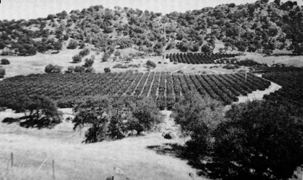
Figure 1. Mediterranean
grasses sweep down to an orange grove on Highway 180 near the Sierra Nevada
foothills. The influence of the Spanish
extends well beyond the areas they actively settled and used. Photograph by W. Preston.
Colonial
peoples also carried domesticated animals such as cattle, horses, sheep, and
fowl to California. Livestock numbers
quickly grew to enormous proportions in the mission realm and spread into the
state’s interior (Hornbeck 1983, 54-55).The impacts of these animals on plants,
animals, soils, and watersheds were additive to the changes wrought by the disruptions
of wildlife (Burcham 1957, 186-88; Schoenherr 1992, 718). Periodic droughts exacerbated the devegetation
and soil erosion caused by overstocked ranges (McCullough 1969, 15). Today, the residuals of these effects are
still observed in much of the gullying found in the coastal ranges and on the
margins of the Central Valley (Latta 1936).
The
presence of colonial livestock influenced subsequent economic pursuits and
their contemporary landscape expressions.
Owing to the Spanish and Mexican preference for domesticated animals as
well as their late colonial ubiquity, many early Americans viewed much of the
state as suitable only for livestock ranching.
As a result, the San Joaquin Valley was initially utilized as a great unregulated
pasture (Preston 1981, 86-87). Many of
the state’s lowlands have now been subsumed by other economic pursuits;
however, the legacy of traditional livestock ranching remains visible in
contemporary landscapes. One fifth of
the state’s land is currently used for grazing livestock (Peters et al. 1998, 302) and their terraced trails show
prominently on hillside lands. Barns, fences,
and corrals are ubiquitous in many rural areas.
California’s long history of ranching has altered a variety of physical
environments that range from valley riparian areas to mountain meadows in the
Sierra Nevada. The livestock industry accounts
for the alfalfa and some of the feed such as yellow corn,
that grace the state’s agricultural regions. Furthermore, livestock raising
has directly contributed to the presence of thousands of small dams, ponds, and
wells that appear on rangelands. Indeed,
agriculture is the foremost consumer of fresh water in the state and the
livestock industry demands the largest share of it (California Department of
Water Resources 1998, 4-26).
The
origin of many of the altitudes, practices, and institutions that have contributed
to California’s evolving landscape can also be traced to the colonial of the
Spanish. The Spanish as well as other foreign
peoples arrived in the state with environmental attitudes that were considered different
from those of the native inhabitants (Preston 1997, 264).
They
viewed the state’s physical resources initially as inexhaustible and entirely divorced
from their own spiritual existence. As a
consequence, colonial people possessed few inhibitions about changing the
physical environment for the purposes of settlement, economics, and sport. Both sustained commercial forestry and irrigation
began in the colonial period (Clar 1959, 12-44; Hornbeck 1963, 51-53). Furthermore, some of the rules that governed
the exploitation of natural resources survived to influence post-colonial
landscapes. As David Hornbeck (1990, 51,
60) explains, the “principles of mining, irrigation, water, and property rights
of women stem from the Spanish regime...and the large corporate farmers of
California share in a common water-rights system that is a thinly disguised copy
of Spanish water law. Indeed, the state’s
ultimate adoption of “the doctrine of prior appropriation” as the legal framework
for water use resembled the Spanish water law and allowed for the vast irrigated
landscape currently observed (Hundley 1992, 72).
The
initial Hispanic settlement infrastructure is also strongly reflected in California’s
contemporary pattern of roads, settlements, tourist destinations, property
boundaries, and architecture. A number of
colonial transportation pathways provide routes for important highways and roads. The conformance of Highway 101 with long
portions of El Camino Real is a noteworthy example. The pueblos, missions, and presidios served
as nuclei for most of California’s largest urban areas. Today over seventy percent of the state’s
population live in one of the twenty-eight sites originally founded by Spain
(Hornbeck 1990, 61). Many of California’s
twenty-one missions are important tourist destinations and they generate a host
of landscape elements in the form of advertising and urban and roadside
businesses. Furthermore, portions of the
boundaries of many of the hundreds of ranchos that were granted during the
colonial period have influenced the spatial patterns of countless urban and
rural roads, fences, trees, power lines, and town boundaries in coastal regions
such as the Santa Clara Valley (Broek 1932, 86, 94).
Most
of the foregoing landscape expressions of California’s colonial past are restricted
to the western portion of the state. However,
the adoption of colonial themes in built environments is more spatially
pervasive. The aesthetics of the Hispanic
architectural legacy (e.g. mission revival, arroyo culture, and ranch-style
houses) are significant and increasingly common attributes of domestic and commercial
landscapes (Pitt 1970, 29l-96; Starr 1973, 390-414; Rice et al. 1996, 165). Housing tracts replete with red tile roofs
and Hispanic decor for fast food outlets and banks are typical examples of the
heritage, appeal, and timelessness of the state’s colonial legacy. (Figure 2) Also in many rural and urban areas are
signature elements of a cultural scene created by todays Hispanic residents. Although most settled California after it became
American, they represent continuity in Spanish heritage that lies heavily on
the visible landscape.
Figure 2. The use of El Camino Real as a modern highway and Spanish
style roofing in late twentieth century architecture are two persistent
landscape legacies of Spain shown here in Atascadero. Photograph by W. Preston.
Figure 2.
The use of El Camino Real as a modern highway and Spanish style roofing in late
twentieth century architecture are two persistent landscape legacies of Spain
shown here in Atascadero. Photograph by
W. Preston.
The
story of the California Gold Rush with its compelling and romantic character is
one of the most exhaustively researched topics in the West. Its inauspicious start, its ephemeral and unbalanced
economic focus, and the mania that drew 250,000 people to the state in less
than three years have become part folklore, part cultural genealogy (Gressley
1999; Holliday 1999; Paul 1947; Rohrbough 1997). Nobody denies its profound historical consequences
not only for the region, but also for the nation and the world. Yet, two years ago, on the occasion of its
sesquicentennial, several historians disputed its lasting effects on the modern
state. Richard White (1998) posited that
its immediate effects were superseded by later economic, demographic, and
political processes. Others added that
the transport, agriculture, and industry it brought would have come anyway to such
a resource rich state (Bethel 1998). However,
the discovery of gold ignited processes of economic development, settlement,
environmental modification, and political adaptation that have spatial and
visual resonance in California’s landscape of today.
The
most recognizable landscape legacies of the mining era are the mines, towns,
water systems, and transport links that litter the foothill and desert districts
of the state. Mining directly established
the settlement framework in those otherwise undesirable nineteenth century
locations. In Amador, El Dorado, Nevada,
and Placer counties, the major towns, including all four county seats, and the
roads that link them, began as parts of the gold rush infrastructure (Dilsaver
1982, 400-103). The historic character
of towns like Auburn, Nevada City, Sutter Creek, and Sonora has made the Sierra
foot hills the fastest growing part of the state (Figure 3). Even abandoned towns, like Bodie and
Columbia, entertain thousands of tourists and sustain a nostalgic idyll that
draws the new rush of mobile workers and retirees. Mining towns are among the most recognized of
historic landscapes in the country. They
display a convoluted morphology and historical authenticity that stem from
their adaptation to geomorphology and their unsuitability to functions other
than tourism and telecommerce.
The
abandoned infrastructure of mining is also present in these zones. The ruins of conveyors, mills, sluices, and
equipment, and tell-tale piles of debris spotlight thousands of former
mines. Due to their structural
instability and the frequent presence of dangerous chemicals, state and federal
agencies seek to identify and rehabilitate these sites. The Bureau of Land Management
(1996) estimates that its lands alone (13.8% of the state) contain 11,500 “Abandoned
Mine Land” sites. Miners dug or constructed
more than 7000 miles of ditches and flumes, among the earliest in the state. In many cases these also lay in ruins. However, these early water engineers also included
sources and water transport routes in the mountains that have been adapted for modern
use by towns and agriculture (Rohe 1983).
Their accession to high mountain water sources
and elaborate distribution systems helped pave the way for California’s
adoption of appropriation and massive agricultural irrigation a few decades
later.
Mining
also helped plot the settlement pattern and urban character of California. Gold
mining established the relative importance of Sacramento, San Francisco, and
Stockton. Sacramento became the state
capital based on its role as a mining supply center. San Francisco dominated banking and mining
finance. The presence of mining wealth
drew entrepreneurs who brought the state’s earliest industry to the Bay Area
and shaped its characteristics of light to medium assembly and consumer products
(St. Clair 1998).The crowded and vertical financial district of today’s San
Francisco lies atop sunken gold rush ships.
Limerick (1998) suggests that California’s urban focused population also
stems from the entrepreneurship and manufacturing derived from the mining industry. Furthermore, the distinctive Asian landscapes
within California’s largest cities ultimately owe their origins to Chinese
gold-seekers.
The
environmental effects of mining have been the topic of intense study and comment
since the time of the gold rush. Grove Karl
Gilbert (1917) calculated that the industry, especially through hydraulic
mining, had deposited more than 1.6 billion cubic yards of sediment dwarfing
the amount generated by natural processes and other human causes such as
agriculture, grazing, and deforestation.
The channel bottoms of some mountain streams rose several inches per
year. In some cases river channels moved. Vast outwash deposits lay over the Sierra
Nevada piedmont. Towns and agricultural fields
flooded. The bed of San Pablo Bay rose
more than three feet and 9000 acres of tidal mudflat were created around its
edges. Mine sites like Malakoff Diggings
at North Bloomfield became moonscapes as hydraulicking carved away these vast
sediment loads (James 1994; Rohe 1983; USGS 2000).
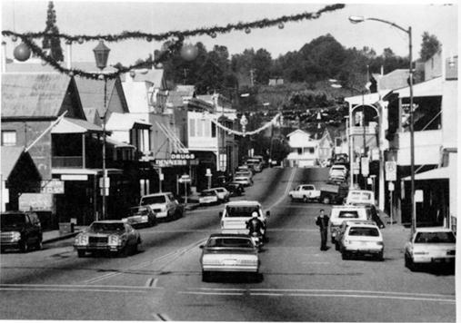
Figure 3: The
historic landscape of the Mother Lode is well represented by the town of Sutter
Creek. Photograph by L. Dilsaver.
Modern
research has shown that erosion and revegetation have ameliorated much but not
all of this amazing landscape disruption.
Rohe (1983) suggests that six feet of debris along the Yuba River is
probably permanent. James (1994) found
terraces formed by mining debris where rivers recut their channels into the raised
beds. He concurs that they are “permanent
over centennial time scales.” All modern
researchers agree that many millions of cubic yards of sediment still line
Central Valley rivers (USGS 2000). Dredging overturned much of that sediment and
left it in parallel rows of man-made eskers.
Dredge spoils cover dozens of square miles along Sacramento River
tributaries. At hydraulic mine sites,
vegetation has reclaimed some cuts and tailings while others remain largely
barren.
Mining
introduced many other environmental impacts, some of which shaped the landscape
in unexpected ways. Dasmann (1999) found
that the mining era wiped out much of the large mammal population, especially
bears. The latter are noteworthy because
they function as ecosystem engineers in their natural habitats moving soil,
uprooting trees and logs, dispersing seeds, and preying on other species (Lawton
and Jones 1995). Mining, like no other
function, impacted the fauna of mountainous areas where many minerals concentrated. At Grass Valley the collapse of shafts and
slopes in the Empire Mine caused surface subsidence noticeable to anyone
driving its streets. Most of the
deforestation that raised the foothills tree line by up to 2000 feet and
decimated the Tahoe area has been reversed. Yet the forest composition has been altered. In semiarid areas chaparral and digger pine
often replaced ponderosa pine (Rohe 1983).
The
gold rush also shaped the politics and culture of the state in ways that show
in the landscape. The rush drastically accelerated
Indian displacement or elimination. The
widely scattered distribution and small size of reservations in California are
byproducts of the geographically expansive search for wealth (White 1998). The international
character of the rush brought large numbers of Chinese to California, resulting
in enclaves of mixed Chinese and American appearance in most major cities.
The
disorganized society of the early mining camps led to social attitudes and laws
that have landscape expression. Batabayal
(1998) suggests that they spawned an “economic liberalism” that decries
government influence in use of public lands.
Later Congress institutionalized this in the Mining Law of 1872 (30 USC
21-54 as amended). Among the effects of
this sweeping law are more than 27,500 extant mining claims on federal land in
California (BLM 1996). The California
Division of Mines and Geology reported 917 active mining operations in the
state during 1995 (Youngs 1996). Individuals
hold most of the remaining claims. As
early as 1944, the Forest Service reported that 21 percent of the claims on its
lands were used for residential or commercial purposes (Friedhoff 1944). The agency now estimates that more than half
the mining claims in the national forests are used for these purposes (Stone
2000). Thus, much of the infrastnrcture
on California’s federal lands owes its existence and distribution to a system
of egalitarian and economically liberal laws devised hurriedly amid the placer
mines of the state.
One
final impact of the gold rush’s legal legacy can affect the landscape in ways
as startling as the hydraulic operations of twelve decades ago. Major corporations use the gratuitous Mining
law of 1872 to open-pit mine for gold. Some
companies confidently plan to pulverize entire hills and retrieve the gold by a
chemical process known as heap leaching.
A landscape left behind by this operation will have its physiography,
soil profile, and biota dramatically altered.
Furthermore, as scientists ponder the significance of the world’s most
acidic water at Iron Mountain near Redding, both the landscape and the health
consequences of mining’s chemical residue remain unknown.
When
California joined the United States in 1850, it became part of the nation’s
public domain and subject to the federal laws governing cadastral surveys. Congress enacted the law of the land, now
known as the United States Public Land Survey or Township and Range System, on May
20th 1785 (Thrower 1966, 4). Sixty-six
years later, on July 17th 1851, a contract surveyor named Leander Ransom
inaugurated the survey in California by establishing an initial point on Mount Diablo
(White 1982, 115). This solitary act initiated
a process that has shaped landscapes throughout the state.
The
Public Land Survey is noteworthy for its geometric organization and grounding
in coordinates of latitude and longitude.
Two sets of lines govern the grid.
A north-south line, or principal meridian, intercepts an east-west parallel,
or base line, at the initial point. Running
parallel to both the base line and principal meridian are lines that form a latticework
of rectangles that are called townships.
Each township incorporates thirty-six square miles and is, in turn,
subdivided into square mile sections. Furthermore,
each section is progressively quartered into smaller and smaller geometric units
(Campbell 1993, 171). Three initial
points, including the original monument at Mount Diablo, were utilized to map
approximately eighty-two million acres, or about four-fifths of the state. The only portions of California not mapped in
this fashion were the colonial ranchos, the Channel Islands, and certain
mineral lands (Uzes 1977, 147-148, 157; White 1982, 117). The main intent of the survey was to exactly
describe and identify land so that it could be readily transferred by the
United States, by the State of California, and by private individuals.
The
Congress of the United States enacted a number of land alienation policies -
the body of laws that govern land transfers - that assisted in the distribution
of the public domain to state and private concerns. Many of these measures, such as the Homestead
Act of 1862, allocated parcels of land concomitant with the quarter sections of
the Township and Range System. Furthermore,
the Land Ordinance of 1785 also contained provisions for the transfer of larger
units such as the full sections granted in considerable numbers to the Southern
Pacific Railroad. However, in an effort
to inhibit the monopolizing of land in large contiguous units, only alternate
sections were initially available for ownership by any individual concern (Johnson
1976, 143). These alienation policies
and their cadastral context are visibly distinguishable on the landscape today.
In
the San Joaquin Valley, for example, the moister eastern regions were settled
relatively early during the 1850s and 1860s as the public domain was transferred
to homesteaders through a variety of alienation acts (Eigenheer 1976, 275-284).
Although these initial land ownerships
were relatively small, the cadastral framework assured that farmsteads were
spatially scattered and isolated from those of neighboring landholders (Jordan-Bychkov
1999, 79). On the other hand, where
alternate railroad sections were present in the Central Valley, these lands were
initially unavailable or avoided by early immigrants. Later, in the 1870s and 1880s when the rail
road owners began selling off the sections that had been previously granted to
them, landholders from adjoining sections or newcomers to the region began purchasing
the available land in larger units. This
explains why in some rural areas of California east of the coast range there are
fewer farmsteads and associated settlement forms visible in sections once owned
by the railroad (Preston 1981, 109).
Visual
contrasts between alternate sections of townships are apparent in a number of
other locations in California. A case in
point is the pattern of planned housing developments in the Mojave Desert. Contrasting landscapes between alternate
sections are distinctly revealed in the vicinity of California City where
subdivided sections containing roads and houses are interspersed among sections
of desert. Similarly, oil drilling and
pumping in western Fresno and Kings counties began on
alternate sections during the first decades of the twentieth century. Since then, oil development has spread in
some areas to adjoining sections, but the checkerboard contrasts between the
landscapes of oil and ranch or farm land still exist (Jennings 1953).
The
Public Land Survey has contributed both directly and indirectly to the
contrasting landscapes between certain regions of the Great Central Valley. In
contrast to the east side, a much greater portion of the land on the west side
of the valley was monopolized during the 1860s and 1870s. Owing to the inaccurate environmental assessments
of the original surveyors, the availability of land, and the fraudulent use of
alienation policies such as the Swamp and Overflowed Lands Acts and Military
Scrip, the public domain on the west side was acquired by relative few
claimants (Eigenheer 1976, 312-320). Land
speculation was often the motive for these endeavors, and resulted in the
removal of huge portions of the public domain.
Most notorious among the monopolists was Henry Miller whose acquisitions
included a one hundred mile stretch of land along the San Joaquin River
(Robinson 1979, 192-193). The
contemporary legacy of his and other land monopolies during the nineteenth
century is readily visible in the extensive corporate landscapes that contain
larger fields and fewer homesteads than the rural landscapes on the eastern
side of the valley (Preston 1981, 111-112).
An indirect consequence of this division is that settlements on the west
side of the valley such as Mendota and Corcoran tend to be more impoverished
than those in the east as fewer landowners contribute less to the local economy. The corporate settings on the west side are
largely responsible for these economic and settlement disparities and the
visible landscapes of poverty bear testimony to the linkage between the Public
Land Survey and community health (Goldschmidt 1978).
Perhaps
the most striking contemporary legacy of the Public Land Survey is the visible
geometry of rural California (figure 4).
In the flatlands it imparted rectangularity to the landscape that is
visually inescapable. Public jurisdictional
boundaries (e.g., parks, forests, military bases, national monuments, wildlife reserves), property lines, homesteads, fences,
roads, canals, field and orchard patterns, and even a few water bodies dearly
demarcate the cardinal orientation and checkerboard fabric of the cadastral
system. The settlement infrastructure
conforms particularly well to sectional boundaries, its rectangularity
intensified through subsequent farm fragmentation and consolidation. In more densely populated areas, section
lines serve as the framework for continuing subdivision.
County
roads in the Central Valley, for example, usually conform to sectional and township
boundaries. Many straight north-south roads
make an abrupt right angle jog where they encounter the survey correction lines
that occur every twenty-four miles north and south of a base line (Greenhood
1971, 25). Even interregional roads such
as Highway 99 and Interstate 5 in the northern San Joaquin Valley are congruent
over extensive stretches with the adjoining sectional or township boundaries
(Johnson 1976, 143; Johnson 1990, 137-141).
The
impact of the Public Land Survey is equally impressive among urban landscapes
where variations on the rectangular grid pattern sometimes occur. A number of
settlements established by the railroad exhibit a rectangular street framework
oriented to the tracks rather than to the cardinal directions inherent in the
survey. However, once successful railroad towns expanded into the countryside,
developers commonly broke from the original cadastral orientation established
by the railroad and built in accordance with the Public Land Survey. The street
patterns of Modesto and Fresno, like those in most railroad towns, display this
phenomenon.
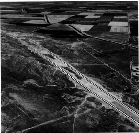
Figure 4. Figure 4. The
familiar checkerboard pattern of the Township & Range land division system
is especially pronounced in flat areas such as the San Joaquin Valley near
Kettleman City. Photograph provided by
the California Department of Transportation.
In
towns and cities that have strictly adhered to the geometric dictates of the
Township and Range System, its influence extends to all aspects of the human
landscape. Even the smallest features
such as town lots and the organizational geography of homes, yards.fences, and
driveways in these communities are oriented to the straight lines of the survey
system. Its impact is evident, as well around
the expanding margins of California’s burgeoning cities. Cities grow at the.expense
of open countryside and in the process adopt the configuration of pre-existing
cadastral patterns. In this fashion,
urban boundaries spread along the edges of sectional roads before filling in
the development tracts (Jordan 1982, 54). Moreover, land incorporated for urban
expansion is usually acquired in rectangular units of varying sizes that is, in
turn, a legacy of the survey’s influence on ownership patterns. As a result, the distinction between new urban
developments and the rural hinterland is often stark and delineated in
conformance with the cardinal directions. The zones of suburban growth around downtown
San Bernardino and Sacramento, for example, are distinct for their miles of rectangular
blocks and uniform streets.
After
dark, the rectangtangularity of urban lights is one of the most prominent and
singularly striking patterns of California’s nightscape. This nocturnal panorama is especially impressive
from an elevated perspective offered by highlands or aircraft. Indeed, the westward descent into Los Angeles
International Airport at night provides unsurpassed visual testimony to the
sinews of the Public Land Survey.
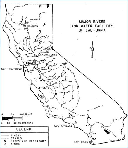 Figure 5:
The major federal, state, and local water transfer structures in
California. Source: California
Department of Water Resources.
Cartography by Margarita K. Pindak
Figure 5:
The major federal, state, and local water transfer structures in
California. Source: California
Department of Water Resources.
Cartography by Margarita K. Pindak
During
the early years of the gold rush, San Francisco grew so rapidly that by 1852 it
had outgrown its own local supplies of fresh water. In that year the city
approved a petition to tap a source of permanent water from another drainage
system. After several delays and changes
to the original plans, in 1858 water was transported by flume from Lobos Creek
five miles to the mains of downtown San Francisco (Delgado 1982, 31-35). On completion of the project, San Francisco became
the first major municipality in California to receive a pennanent water supply
from another watershed. The tapping of Lobos
Creek provided the precedent that inspired subsequent efforts to acquire more distant
and widespread sources of fresh water by San Francisco and other urban areas throughout
California (Figure 5). California’s exceptional
urban growth may be traced to it and few events have initiated processes more
importan to the shaping of the state’s contemporary landscapes.
The
Lobos Creek diversion and subsequent projects allowed San Francisco to increase
from a pre-gold rush population of 300 in 1846 to 80,000 by 1862. Additional water was again required, and the
cit y expanded its infrastructure to impound and import more water. First from the peninsula to
the south and then from the southern East Bay (Leonard 1978, 38-39, 42-43).
By 1900, the city had reached a
population of 340,000 and was now looking to the Sierra Nevada, and
specifically the Tuolumne River, for additional sources (Hundley 1992, 120,
169-170). The lynch pin of the Tuolumne
system would be the damming of Hetch Hetchy Valley in Yosemite National Park
(Kahrl 1978, 29-31; Brechin 1999, 71-117). After considerable controversy, San Francisco
was victorious and by the early 1930s was importing most of its municipal requirements
from the Tuolumne watershed through the 148 mile long Hetch Hetchy Aqueduct. For years following the initiation of the
project the system continued to be upgraded with a spectacular array of
tunnels, dams, pipelines, inverted siphons, and powerhouses.
Imported
water provided San Francisco with the ability to modify national parks,
national forests, cities, and farmlands.
Reservoirs such as Hetch Hetchy, Crystal Springs, Don Pedro, and Calaveras
cover hundreds of square miles, and the intervening landscapes are laced with
pipelines, powerhouses, and transmission lines.
Many of these facilities and their rights-of-way boast a variety of recreational
functions including camping, hiking, boating, and fishing (Benchmark Maps 1998,
14-17). These attractions, in turn, have
generated an array of business and administrative landscapes along access
routes and within gateway communities. San
Francisco’s jurisdictional authority to dictate land use and management practices
around the project’s facilities is extensive.
The city has considerable land and water rights in a number of peninsula
and southern East Bay counties and county, state, and federal fiats guarantee its
influence over other lands. One result
of this control is maintenance of open space by the city in some Bay Area
suburbs (Brechin 1999, 88; Leonard 1978, 24-25).
Although
Tuolumne water temporarily renewed San Francisco’s urban growth, further
expansion was eventually curtailed more by political and physical constraints
than by a lack of water. Nevertheless,
the city’s influence is still felt in its ability to control water resources
and as a precedent for other metropolitan environments. San Francisco currently possesses substantial
water and power surpluses and it sells the excess to nurture continued urban
expansion in more than fifty neighboring communities. Virtually all of San Mateo County’s
residents, for example, depend upon water sold to them by San Francisco (Leonard
1978, 25; Selby 2000, 194). Additionally,
the East Bay Municipal Utility District (EBMUD) mimicked San Francisco’s urban
water system and imported Sierra water from the Mokelumne watershed. This water in turn continues to fuel urban
expansion in the vicinities of Walnut Creek, Concord, and Danville and the
growth has inspired EBMUD to consider other distant sources such as the Feather
River (Littleworth and Garner 1995, 9-10).
The
urban water system in Southern California conforms to the overall pattern of San
Francisco’s diversion of the Tuolumne and the East Bay’s diversion of the
Mokelumne River; however, the impact is of a greater magnitude. Control of the watershed of the Los Angeles
River had sustained Los Angeles in its youth.
However, by the end of the nineteenth century, Los Angeles had nearly
exhausted its ability to extract more water (Gumprecht 1999, 41-81, 85-129). To sustain growth and prosperity, the city
tapped the streams and ground water from the Owens and Mono Basins far to the
north by constructing the Los Angeles Aqueduct.
This storage and conveyance system is half again as long and delivers nearly six times as much water as San Francisco’s Hetch Hetchy
project. The landscape impacts in the
areas of extraction and consumption are far greater as well (Kahrl et al. 1978,
51).
The
aqueduct allowed the population of Los Angeles to increase twelve fold and expand
in area ten fold between 1900 and 1950 (Kahrl 1976, 115). Like their counterparts in Northern
California, the storage and conveyance facilities have spawned bountiful
recreational and commercial landscapes (Benmmark Maps 1998, 19, 25, 25). However, the consequences of urban water
extraction have inflicted unparalleled changes on preaqueduct environments. Due to the Los Angeles diversion, Owens Lake
is completely drained and Mono Lake severely depleted. The exposed lakebeds and shorelines are
disconcertingly dramatic, and the sky over the southern Owens Valley is now
turbid with dust. Moreover, the
modification and elimination of riparian vegetation in the Owens Valley and along
the former courses of Mono Basin’s diverted streams are notable byproducts of
the aqueduct system (Gaines and DeDecker 1982; Reisner 1993, 101). The Los Angeles Department of Water and Power
(DWP) exercises jurisdiction over 300,000 acres of land in Owens Valley and
continues to curtail urban expansion around settlements such as Bishop and condone
the deliberate removal of numerous rural farmsteads. Furthermore, the fields of irrigated crops
that once carpeted the valley have been rendered into scrublands and pasture
(Hart 1996).
Unbridled
urban expansion in Los Angeles and other cities in southern California
immediately prior to and following World War II created the need to import
additional water from the north by the California Aqueduct and from the east by
the Colorado River Aqueduct. Although
the majority of the water is utilized for irrigation elsewhere, the Colorado
River serves water to over fourteen million people inhabiting 500 cities spread
over 5000 square miles (Selby 2000, 199).
As a consequence of this fresh abundance of imported water, Los Angeles
doubled its population again between 1940 and 1970 (Kahrl et al. 1978, 42). Furthermore, its neighboring cities
stretching from Ventura to San Diego have expanded even faster, sustaining rapid
growth into the twenty-first century.
Many
settlements in California require varying amounts of fresh water from
subterranean sources. However,
interbasin water transfers have supported most of the state’s urban expansion
and sustained a booming economy. Indeed,
cities over large areas of the state have benefited from water projects that were
constructed primarily for agricultural purposes such as the Central Valley
Project. Since San Francisco’s fateful
diversion of Lobos Creek in September 1858, California cities have contributed heavily
to the construction of over 1300 dams and associated facilities currently
scattered throughout the state (Selby 2000, 194, 203, 209). This reciprocal relationship between cities
and water is a driving force behind the state’s continuing population explosion
and the expansion of its urban landscapes.
Most
of California’s 54 million people live in suburbs, and the resulting landscapes
have fundamentally refashioned the visible scene. The state’s most extensive suburban
landscapes ring Los Angeles, San Francisco, and San Diego where the vast
majority (70-80 percent) of the urban population lives beyond the boundaries of
the central city (Kenworthy and Laube 1999).
Similar sprawling collections of dispersed housing, two-car garages,
backyard patios, commercial strips, and shopping malls can also be found from
El Centro to Redding. Much of today’s
suburban landscape has been created since 1950, although the roots of
California’s suburbs extend well back into the nineteenth century. The penchant for escaping central cities was
already apparent in the vicinity of New York City as early as 1810 (Brooklyn
Heights) Jackson 1985, 25-50). In
California, the 1864 completion of a rail line from San Francisco to San Jose
spawned the first generation of suburbs (Burns 1977, 1980). Bay Area elite were attracted to the pastoral
lifestyles and low density housing of planned suburbs such as Burlingame and
Atherton. It was the beginning of a
landscape-shaping process that continues unabated almost 150 years later.
California’s
suburbs have enduringly altered earlier landscapes. Where suburbs have sprouted in valley
settings, they have often consumed huge tracts of agricultural land. Indeed, over 25 percent of the state’s best soils
are now covered by urban or suburban land uses.
For example, Los Angeles County lost over 45,000 acres of citrus land to
suburban growth in the ten years following World War II (Nelson 1959, 80;
Banham 1971, 161-77). As suburbs
multiply, suburbanites bring in thousands of exotic trees, plant extensive
lawns, displace native animals with their suburban pets, and forever alter the fundamental
ecological setting (Price 1959; Streatfield 1977). Foothill environments, including many around the
Bay Area as well as inland Southern California, have also been dramatically
altered by suburban growth (Banham 1971, 95-109). Natural vegetation has been encroached upon,
and drainage and topography have been reconfigured to suit the needs of the California
hill-dweller. Frequently, such settings
are also the scene for fire and flood damage, a reminder that the natural landscape
is not infinitely malleable to meet human needs.
Why
are suburbs where they are on the California landscape? Dozens of suburbs owe their origins to the
geography of nineteenth-century interurban rail lines that radiated from major
cities such as San Francisco and Los Angeles.
Indeed, southern California boasted over 1100 miles of rail network and these
links encouraged suburban growth in places such as the San Fernando Valley, Pomona,
and Anaheim (Bottles 1987). Other
suburbs popped up near industrial activity that sprouted beyond the boundaries of
traditional cities (Hise 1997; Matthews 1999; Viehe 1981). For example, Brea and Fullerton appeared near
oil fields, Burbank grew in response to the movie and aerospace businesses, and
San Jose benefited greatly from high-technology industries in Silicon Valley. Real estate promoters have also shaped the growth
of the suburban landscape. Southern
California’s real estate boom of the late 1880s produced more than 60 new
suburbs. While some vanished,
communities such as Glendale, Monrovia, and Redondo Beach owe their origins to
such activity (Nelson 1959; Streatfield 1977a).
Throughout the state, however, the automobile and its associated road
network have undoubtedly exercised the greatest influence on the location and
spatial extent of California’s suburban landscape (Foster 1975; Meinig 1979). Between 1920 and 1950, the automobile’s
flexibility encouraged the infilling of open space between older discrete,
suburban communities on the edge of major cities. Since 1950, powered by spreading freeway
construction, the automobile has enabled much more suburban growth often 40 to
60 miles or more from the central city (figure 6). Today, Tracy and Manteca have become Bay Area
suburbs, while Temecula and Moreno Valley are within the ever-spreading reach
of Los Angeles (Mcintire 1998, 44-49).
A surprising variety of settlement
patterns and street layouts are associ ated with California’s suburban
landscape (Palen 1995). The curving
streets, abundant foliage, and large lots of the state’s elite suburbs form one
enduring settlement model (Burns 1980; Jackson 1985, 178-81; Streatfield 1977b). Boasting social and spatial exclusivity as
well as an abundance of environmental amenities, settings such as Hillsborough
(near San Francisco), Montecito (Santa Barbara), and Beverly Hills (Los Angeles)
illustrate the pattern. Indeed, Palos
Verdes, a seaside elite suburb near Los Angeles was the carefully planned brainchild
of landscape architect Frederick Law Olmsted.
Another common suburban settlement pattern is the repetitive grid of
cardinally oriented streets, rectangular lots, and mass-produced single-family
housing. This distinctive settlement
pattern expanded greatly after World War II as pent up demand for housing, a
new scale of real estate and building promotion, and an accommodating federal
government (FHA loans and the GI Bill spurred home construction. 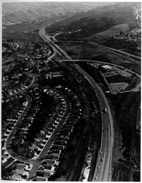
Figure 6. Figure 6. Suburban sprawl clinging to Interstate 680 in Contra Costa County.
The
1950s and 1960s witnessed large development projects in such localities as
Lakewood Village south of Los Angeles and Daly City and Foster City near San
Francisco (Banham 1971; Burns 1977; Price 1959). Many of California’s suburbs, however, have
sprouted since 1970, and these developments have featured more eclectic
settlement patterns. Some have been
shaped by large-scale coordinated planning (Mission Viejo) of street layouts
and land use, while others (San Bernardino and San Jose) offer a varied,
spatially extensive collection of street plans and population densities, often
depending on income levels, local topography, and the tastes of developers
(Abbott 1993, 123-48; Kling, Olin, and Poster 1991) (Figure 7). Some feature the familiar grid, but many
subdivisions also offer curvilinear layouts, cul de sacs, and a greater mix of
single and multiple-family units.
Suburban
architecture is similarly varied. Residential
districts reflect different preferred building styles, depending on income and age
of home construction (Abbott 1993, 123-48; Banham 1971; Meinig 1979; Rubin 1977). Bungalow-style housing, for example,
signifies a neighborhood usually created between 1900 and 1925. Single-story ranch-style housing tracts
multiplied in the 1950s and 1960s, covering many additional square miles of the
California landscape. Elsewhere, higher density
suburbs suggest that rising land costs and changing lifestyles of the past
thirty years have created more demand for apartment, condominium, and townhouse
living.
Added
to this increasingly diverse accumulation of residential architecture are the
varied commercial, retailing, and industrial landscapes that shape the suburban
scene today (Banham 1971; Bottles 1987; Preston 1971; Longstreth 1997). Commercial strips and suburban shopping malls
create a landscape that is mass-produced, franchised, and packaged to meet every
need of the California consumer. Newer
suburban complexes, such as those in Orange County and Silicon Valley, also
offer an ever-growing variety of land uses that is creating a new landscape
some have even described as “postsuburban”.
·Perhaps signaling a common American future, these places are
characterized by multiple regional scale shopping malls, entertainment
complexes, a mix of office parks and space-extensive industrial facilities
(often oriented to the global information economy), a bewildering network of
freeways and multilane surface streets, and a residential landscape, with both single
and multiple-family housing, oriented around convenience, consumption, and personal
privacy (Kling. Olin,
and Poster 1991). As with so many other
elements of the California landscape, these features have created a visible
scene already being widely replicated far beyond the bounds of the Golden State.
Figure 7. Figure 7. The
expansive and repetitive landscape of the California suburb is exemplified by
this tract in Lemoore.
In
1864, the literate American public felt disgust over the privatization and
tawdry development at Niagara Falls. When
it appeared the same would befall Yosemite Valley and the Mariposa Grove,
Congress set them apart as a public park for California (13 Stat. 325). Eight years later, lacking a state to receive
land, another Congress established Yellowstone National Park. Yosemite, however, was the groundbreaker, the
nation’s first state and, in reality, national park. A year after its creation, Frederick Law
Olmsted laid out a management prescription that would become the blueprint and
the philosophy for park systems nationwide (Olmsted 1865). A half-century later the Yosemite grant returned
to federal management while the state pursued redwood lands for new parks
(Engbeck 1980).
Today
California boasts the largest and most diverse state park system in the country. It also has more units of the national park
system than any other state except Alaska.
Twenty-three national park units, totalling 8.1 million acres and 265
state parks at 1.4 million acres comprise more than nine percent of the state’s
land area (figure 8). Together they serve
nearly 120 million visitors per year (California State parks Foundation 2000;
National Park Service 1997). Every
ecological division and a bewildering array of historic themes are
represented. The impact of these many
preserved places on the landscape of California results not only from what they
have wrought but what they have stopped.
The
most important impacts of the parks have been preservation of open space and
prevention of development Golden Gate and Santa Monica National Recreation
Areas and numerous state parks have checked residential sprawl in the state’s
major urban zones. Torrey Pines, Los
Osos Oaks, Crystal Cove, Topanga Canyon, and Mount Diablo are among the state
units with subdivisions lapping at their borders (Figure 9). Point Reyes National Seashore halted a major
tract development after roads and twelve houses had been built. The area of the planned suburb now sweeps
down to Limantour Spit with only three employee houses in view (Duddleson 1971;
Pozzi 2000).
The
presence of a park also has blocked other types of development. After San Francisco builthetch Hetchy Dam in
Yosemite, Congress, in 1921, enacted an amendment to the Federal Power Act
forbidding its implementation in national parks (41 Stat. 1353). In the case of the Kings River, Congress
blocked a Los Angeles reclamation project by adding the area to Kings Canyon
National Park. The Nationa l Park
Service (NPS) and park supporters also blocked several trans-Sierra road
projects, losing only at Tioga Pass. An
ambitious plan to build a high elevation road
along the entire Sierra Nevada also
failed due to NPS opposition (Dilsaver and Tweed 1990, 182-186).
Arguably the most important open space
preserved by the parks is along California’s crowded coast. The California state park system holds title
to 280 miles, or 25 percent of the shoreline.
National parks account for nearly 100 miles more, not including the
Channel Islands. Although all open space
is important, more than a fourth of California’s parklands are designated wilderness. Here the controls on construction and use of
mechanical transport promote a more complete natural signature on the land
(Schaub 2000). 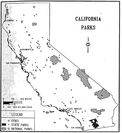
Figure 8Figure 8. National and state parklands in Califonia. Sources: California State Parks and National
Park Service. Cartography by Margarita
M. Pindak
Figure 9. Los
Osos Oaks State Park near San Luis Obispo protects an island of nature amid
residential and agricultural development.
Photograph provided by the Photographic Archives of Catifomia State
Parks
Despite
the preservation of open space, the legacy of human activity is present in all
288 park units. Park management has actively
altered ecosystems while at the same time causing them to diverge markedly from
the lands surrounding them. Among park
managers’ early steps were, first, enjoinment of lumbering, hunting, and most
grazing and, second, suppression of fire.
Parks contain many areas of old-growth forest coveted by loggers. Originally, California boasted nearly two
million acres of redwood groves. Only
86,000 acres remain, 93 percent of them in parks and reserves (Redwood National
Park 2000).
Rangers
practiced extensive fire suppression prior to the mid-1960s. During that time forest composition altered,
sometimes dramatically, especially in the mountains. For example, giant sequoias simply did not
regenerate for nearly a century. In the process,
species like white fir expanded in both range and density of coverage among the
sequoia groves (Sequoia and Kings Canyon 1987).
During that time the fuel load in forests built up to an unnatural level
that has rendered prescription burning a feeble corrective device.
Park
management of fauna has also impacted the landscape. Early efforts to eliminate predators, coupled
with bans on hunting, led to eruptions in ungulate populations. Deer in particular wreaked a devastating
impact on vegetation. The chain reaction
of these ecological changes rippled through communities contributing to near
elimination of some species and increases in others. Subsequent efforts to protect predators, especially
black bear and mountain lions, have led to the further divergence of parkland
ecology from the surrounding areas. Bears,
the aforementioned ecosystem engineers, are densest in the large parks where
hunting is forbidden.
Another
impact of the national and state parks is in preservation of historic structures
and landscapes. Indian settlement sites,
Spanish missions, forts of various groups, and agricultural industrial,
commercial, and even Hollywood landscapes are preserved. Many ethnic landscapes have persisted due to
their inclusion in park zones or to financial support from the state or
national parks. The preservation
movement, begun at Yosemite, led to the 1906 Antiquities Act (34 Stat. 225) for
protection of historic resources. Ironically,
President Clinton recently used it to protect the offshore rocks and islands
along California’s entire coastline (US Department of Interior 2000).
Within
the parks’ auto-accessible zones, planners design buildings and landscapes to
exacting specifications and styles. This
“parkitecture” is duplicated throughout both systems as well as various
regional and local parks. Planners
design campgrounds, buildings, parking areas, and
the disguised infrastructure to
support them to have a “rustic” look that is both carefully wrought and itself
historic (Carr 1998). Still another
influence of the parks extends beyond their boundaries. Most national and state parks are major
recreation destinations. The road system
has evolved to cope with traffic coming to internationally significant sites
like Yosemite and Sequoia, as well as the many accessible beach parks. Gateway towns such as El Portal, Mariposa,
Three Rivers, and Borrego Springs have their own landscapes of
tourism-lodgings, dining establishments, souvenir shops, and a remarkable array
of loosely associated amusements. Parks
in urban zones, with their protected open space, increase the value of adjacent
lands. This, in turn, often leads to
more expensive residential and commercial development. Also, parks and their tourism provide
economic multiplier effects that spawn additional development in surrounding
regions.
Finally,
among the subtlest influences of the national and state parks is their
contribution to environmental education and conservation proselytization. Outside academia, Californians encounter the
environmental message most often in their parks. In some immeasurable way the cumulative impact
of this message surely influences human landscapes throughout the Golden State.
“There
has never been any sustained attack on the idea that the steam railroad was the
most significant invention or innovation in the rise of an industrial society.” So wrote historian Albro Martin in 1992 (12). Califorrnia
History editor Richard Orsi (2000a) is more geographically specific,
labeling the railroad the most important factor in California’s history and
landscape. Invented in Britain, the
railroad came to America when the Baltimore and Ohio Railroad Company was
chartered in 1827 and became fully operational in 1830. California’s first line ran from Sacramento
to Folsom in 1856 (Holiday 1999, 170; Vance 1995, 25-31). However, it was completion of the
transcontinental railroad on May 10, 1869 that brought a major corporate
carrier, substantial land grants, and profound economic, social and
geographical change to the state.
Through establishment of transport routes and towns, development of
land, water resources and tourism, economic impacts on mining, agriculture, and
forestry, and direct formation of both the urban and rural landscape, the
railroads, led by the Southern Pacific (SP), drove California into the
industrial age. Today 30 railroads, most
of them local, still operate on 6341 miles of track in the state. The Burlington Northern and Santa Fe, and the
Union Pacific, two national carriers, own the majority of the track
(Association of American Railroads 2000).
The
spatial array of transportation and settlement in California owes much of its
pattern to railroad planning and construction.
The Central Pacific line over Donner Pass bisected the Sierran mining
region amidst a general and largely irreversible economic decline. It galvanized agriculture and service
businesses, creating a growth corridor. Major
wagon and auto roads followed, as did Interstate 80 (Dilsaver 1982, 184-190, 380-395). Elsewhere, the railroads also laid a tra
nsport network over the state. Interstate
5 in the Sacramento Valley, State Iiighway 99 in the San Joaquin, and large
portions of I-10, I-15, and I-40 in the desert closely parallel the tracks
(figure 10).
Figure 10. National
forests, railroads, and interstates (plus Highway 99) in California. The forests cover the mountainous one fifth
of the state. Many highways followed the
routes of the railroads. Cartography by Margarita M. Pindak.
Along
these lifelines, the railroads established or encouraged numerous towns to
serve as passenger and freight entrepots.
The Central Pacific and, later, the Southern Pacific developed Lancaster
and Palmdale in the Antelope Valley, Livermore and Tracy near the Bay Area,
Mojave and Coachella in the desert southeast, and dozens of market centers in
the San Joaquin including Modesto, Merced, Fresno,Tulare,
and Hanford. Wherever the railroad built
towns, businesses and farmers followed.
In
order to sell their government granted land and provide customers for their
trains, the railroads did everything possible to encourage settlement. The Southern Pacific operated elaborate
planning and marketing departments, both relying on the latest scientific data. It also organized and bankrolled irrigation, farming
cooperatives, forestry programs, and tourism development. One profound impact on California’s modern
landscape is the preponderance of orchards, vineyards, and horticultural fields
in the state’s lowlands. Although many
of these crops arrived with the Spanish, farmer and customer inexperience
hindered their popularity and proliferation.
The Southern Pacific provided settlement assistance, crop research and
education, marketing in the eastern U.S. and Europe, and the nation’s largest
refrigerated rail car system. The latter
was particularly important with the railroad’s successful program to generate
cantaloupe production in the Imperial and Coachella valleys. The SP located and dug the first wells, researched
the cantaloupe as both crop and popular food, built its tracks and towns in the
two valleys, installed refrigeration facilities, taught farmers to grow the
strange crop, and heavily marketed it in eastern cities (Rice et. al. 1996, 282-283,
286-288; Orsi 2000b, Chap. 9; Orsi 1991, 51).
The
railroads also exerted a strong impact on California’s forested landscape. On one hand, railroads deforested some areas
for construction materials and, before 1880, fuel. Additionally, narrow gauge independent or
spur lines spread lumbering and mining especially in the Sierra Nevada. Yet the Southern Pacific, with its long-term planning
and research programs, quickly embraced forest conservation for watershed
protection. SP executives believed both agriculture
and tourism revenues depended on it. The
company played a significant political role in the establishment of national
forests in the state and a technical one through its organization of the first
effective fire suppression system. The
SP also pursued a vigorous program of research, education, and quarantine
during the pine-rust-beetle infestation of the 1900s and 1910s (Orsi 2000b,
chap. 11).
The
important influence of the railroads on national parks and western tourism is
well established (Rothman 1999; Runte, 1990a; Wyckoff and Dilsaver 1999). Encouragement of tourism was a source of
passengers
and profit. California was no exception. Southern Pacific manipulation, much of it
hidden from the public, led directly to the establishment of Sequoia, General
Grant (now Kings Canyon), and Yosemite National Parks in 1890 (Dilsaver and
Tweed 1990; Runte 1990b). Promotion of
mountain recreation and the wilderness experience contributed to more
preservation and tourism development during the ensuing thirty years. It is no overstatement to say that without the
railroads’ influence the wild areas of California would be quite different
today.
Urban
areas too were impacted by the railroads.
Some cities, like Oakland, owe their form and function to them. Older industrial landscapes
Figure 11. Oakland,
like other significant California cities, has a large and impenetrable railroad
yard that shapes the geography of other urban functions. Photograph provided by California Department
of Transportation.
cling to their former lifeline, often near
city centers. Many are now depressed and
crim-ridden neighborhoods. Planning for transportation
and redevelopmen t in railroad cities can be a challenge. Immovable tracks and traffic congestion
during train crossing force adjustments in any spatial plan (Figure 11). Yet, the sprawl of California’s major urban
areas owes its origins to suburban rails.
With the functional, if not financial, success of Bay Area Rapid Transit
(BART) and light rail sytems in San Jose, Los Angeles, Sacramento, and San Diego,
urban rails are becoming more prevalent after years of decline (Figure 12).
Finally,
as we travel through the state, there are the remnant visual scenes at every turn. In the countryside, amid the orchards and specialty
crops, grid pattern town centers orient along the tracks rather than cardinal directions. Loading facilities and silo, many abandoned,
still loom beside the tracks. The rails
themselves impart a linear pattern that disrupts the geometry of the Township
and Range and the polymorphous natural landcape. Lines of trees, planted by the Southern
Pacific for shade, wood, and adornment, can be found on former rail road lands,
along tracks, and at stations extant or remcmbered. They include eucalyptus, tamarisk. black locust, and palms. Some abandoned railroad rights-of-way now
serve as recreation trails. Overpasses
and the occasional tunnel mark the intersection of the rail and auto networks
(Rademacher 1999).
Entering
the dense buildup of the cities a clustering of indutry and warehouses follows
each rail corridor. Large rail yards create
impenetrable impediments to intra-urban flows of cars and people. The periodic traffic jams that accompany a
passing train, added to these other impacts at all scales, demonst rate the
enduring legacy of the golden spike on May 10, 1869.
The
tiny nocturnal glow of Father Joseph Ned’s electrically powered arc light along
San Francisco’s Market Street signaled the beginning of a new era destined to reshape
the California landscape (Brechin 1999, 255-56; Williams 1997, 170). Even as early as 1890, some observers
realized that the harnessing of electricity was “destined to be one of the most
powerful factors entering our social condition (Williams 1997, 168). Indeed, that was the case, and California,
both then and now, led the nation in innovative applications of electricity
technology that enduringly refashioned the visible scene. Californian’s embraced electricity as an
almost mythic symbol of progress upon the landscape: every community wanted the
latest electrical street lighting and trolley systems and every California household
embraced the newest electrical appliances
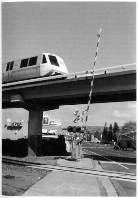
Figure 12.
The California urban landscape, seen here in San Leandro, reflects the
overwhelming influences of railroads and automobiles.
41
that
promised to save time and money (Nye 1990, 1-2). As the demand for the new technology grew, so
did the extensive infrastructure necessary to bring electricity to every corner
of the state. By the early 1890s, the
use of alternating current (A/C) technology allowed for the long-distance movement
of electricity, a breakthrough that immensely stimulated the construction of
hydroelectric power-generating facilities far from where the electricity was
ultimately consumed (Brechin 1999, 255; Williams 1997, 173-177). From that point on, Californians displayed an
unending thirst for power: in 1915, they consumed 2215 million kilowatt (k/w)
hours of electricity; in 1950, the figure had leaped to 24,800 million k/w hours;
and today the state devours more than 268,000 million k/w hours annually (California
Department of Finance 1999; Williams 1997, 374).
The
California landscape is filled with the infrastructure of electricity,
including all of the generating facilities and transmission lines that bring
the power from producer to consumer. The
geography of hydroelectric power illustrates the pattern. As hydroelectricity gained in popularity with
A/C technology, the state’s physical geography preordained an elaborate network
of long-distance connections: California’s major mountain zones, the home of
most of its hydroelectric--generating potential, are typically found at some
distance from the state’s major population clusters (Williams 1997, 169-70). The result has been the construction of an
elaborate series of mountain dams and hydroelectric generating facilities
along with the development of an extensive power grid connecting these often remote
sites to major zones of consumption. For
example, Northern California’s Shasta complex (Sacramento River) and dozens of
Sierra Nevada facilities (including projects on the Pit, Feather, Yuba,
Stanislaus, Tuolumne, San Joaquin, Kings, and Kern Rivers) have reshaped the
state’s mountain geography with a broad assortment of dams, reservoirs, and
power lines. The potential for these
mountain sites was demonstrated in 1901 when Oakland’s streetlights and trolley
cars became powered by waters from the far-off Yuba River over 140 miles away
(Brigham 1998, 3). Later projects were
even larger in scale: the building of the San Joaquin River’s Big Creek Dam,
critical in powering distant Los Angeles, involved the construction of over 56
miles of new mountain access roads, 12 work camps and construction facilities
(later used for maintenance), and over 240 miles of transmission lines to the
Southland (Williams 1997, 184-86). The
Colorado River’s federally financed Hoover Dam project also contained a
critical hydro electric component. By 1939,
it was the world’s largest hydroelectric facility and it allowed Southern
California to increase its consumption of power thereafter (Starr 1990, 157-58;
Stevens 1988, 259). Indeed, electricity figured
into the rationale for building many of the public dams in the West because potential
power sales were used to justify the
42
construction
costs of such projects (Brigham 1998, 12).
Also
facilitating the creation of such infrastructure (both public and private) was
the emergence of large state-regulated public utility companies that
represented the consolidation of many smaller operations. Pacific Gas and Electric (PG&E) formed in
1905 and still dominates electricity generation in Northern California, while Southern
California Edison (SCE), consolidated in 1909 and remains central to
electricity production in the southern portion of the state (Brechin 1999, 264;
Coleman 1952; Starr 1990, 157; Williams 1997, 182-83).
Technological
moves beyond hydroelectricity have also shaped the state’s landscape. Today, only 18 percent of the state’s
electricity is produced by hydroelectric facilities. After 1950, new steam turbine technologies
allowed for the use of fossil fuels in generating electricity and today these
power plants, widely scattered across the state, provide Californians with
their most important source of power (Williams 1997, 277-82). In addition, the state’s nuclear power
facilities in such localities as San Onofre (north of San Diego) and Diablo
Canyon (near San Luis Obispo) provide an additional 15 percent of the
electricity budget (California Department of Finance 1999). The largest visible imprints of so-called alternative
energy production include local solar energy generating units (often atop
individual homes), geothermal power plants (especially Sonoma Counties Geysers
facility), and 27,000 acres of wind-generating turbines (including Altamont
Pass east of Livermore, the Tehachapi Mountains northwest of Mojave, and San
Gorgonio Pass east of Banning) (California Department of Finance 1999; Williams
1997, 288-91, 330-35).
The
consumption of electricity has also radically altered the California landscape. In urban settings, the initial focus of
electricity consumption (in the 1880s and 1890s) came in the form of electrified
streetcars and street lighting (Brigham 1998, 3; Nye 1990, 69-137). Although the streetcars have largely
vanished, many of the key urban commuting routes they created remain as
principal urban and suburban thoroughfares today. The modern nocturnal illumination of the city,
of course, remains an enduring legacy. Californian
historian Kevin Starr describes the transformation of Los Angeles by the
1920s:·Nighttime Los Angeles had become a wonderland of light. From atop Mount Lowe one beheld Los Angeles, Pasadena,
and fifty-six contiguous cities and suburbs spread out in a vast sea of
illumination. In sheer extent…there was no
other spectacle like it in the United States (Starr 1990, 157) (Figure 13). Gradually, between 1910 and 1930, residential
use of electricity for lighting and home appliances added to the twinkling of
urban consumption patterns (Nye 1990, 238-86).
In a more subtle fashion, electricity also
43
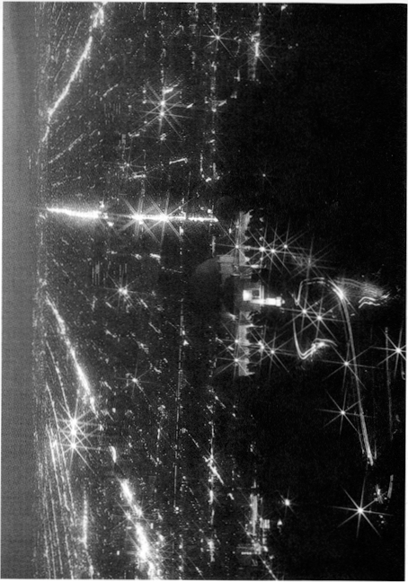
Figure 13.
Los Angeles at night is an electric landscape that can be seen from space
Postcard from the collection of W. Wyckoff.
44
made
possible fundamental reconfiguration of California’s factory layouts, a transformation
that remains apparent today (Brigham 1998, 134-38; Nye 1990, 185-237; Williams 1997,
203). With widely available electrical power,
factories could be designed to be more hori1zontally extensive and less
dependent on centralized steam-generating facilities. Indeed, after 1910, new industrial plants in
California widely adopted the approach, which often included the use of
longitudinally extensive and more efficient assembly line manufacturing
processes.
In
the countryside, Californians rushed to electricity more quickly than any other
rural Americans (Nye 1990, 23-25). By 1934,
60 percent of California farms were electrified, while the national total stood
at only 11 percent (Williams 1997, 222-23).
One enabling factor for many California farmers in the Central Valley
was the close proximity of electricity in the form of transmission lines that connected
the Sierra Nevada with the state’s urban areas.
Tapping into this grid allowed California farmers to vastly expand their
use of electric irrigation pumping that allowed for the continued elaboration of
the agricultural landscape (Smil 1994, 188-91; Williams 1997, 224-231). By the late 1920s, over 12 percent of the
state’s total electricity consumption came from pump irrigation operations and
this technology remains essential today in providing water for many California
farmers. In addition, electric motors have
proven pivotal in modernizing many other farming activities, including the use
of new milking machines, poultry brooders, and refrigeration facilities. Indeed, from the state’s rural periphery to
its brightly illuminated downtowns, electricity has enduringly reconfigured the
cultural landscape of the Golden State.
Artificid
l i rrigol ion lhH been the
mainsldy of econom ic prosperi ty in
California. ll owever, unt il the
passage of the Wright Act (Asscmbly
Bill
12) on
1\’larch 7, 1887, few farn1ers
had the legal or pr. tllic,ll means to
obtain stream w. oter for irrigation. The legislative p.
1ssage of the I Vright Act not only ov(·rcanw this barrier. but also pavL’(l the way for the rapid expansion of irrigated agriculture in Californiu.
During the first dcc. 1(lcs of statehood. the right to t•xploit
stre,1m water was innuenced br English common
law. Spanbh praoiu-s• •md
gold rush inno,•ation. Unclrr the former. thedoctrine of-rip. 1ri. m rights• prevailed in England . md the eastern United States. This prinripk
hrld th.
ot only
those people l iving on a stream
bank could l. 1y cl.
oim to it . California offici(lly o doptc·d
thi. , wmmon law in 1 850, but gold \l’t•kcrs found it unsuitabk for hydrc ulic min i ng. They adopted lhC’ (mlom known as
•appropl’ic tion. " Kc,t’rnbl ing ll ispanic
walc·r I,Hv, thr approprio tion
-15
doct rine dictat(•d that many people could divert stream water
for bcncfocialuscs with priority
going to the forst comer. In 1851, California
also endorsed appropriation in the gold country and ultimately incorporated both dodrines
into statewide law in 1872.
The legislative willingness to accommodate
these contrary doctrines caused considerable
confusion and litigation (‘Specially concerning C(OJ> irrigation (Bundley
1992. 67-85). The jurisdidional
uncertainties, anger over land monopo
lists.
and the inability of small landholders to afford to construct
and manage irrigation projects,
in turn. resulted in the pass( ge
of the Wright
Irrigation District Act in 1887.
The
Wright Art dulhorized residents in an nrca to org(111ize irrigation
districts, purchase
land and water rights, and dist ri bute water. hnpor t nl l ):·the d i;tricts cou ld condemn
all individua
l Willer rights. includ ing
nparoan, and pu rchase them in the name of the district .
Once the obstacle of ri parian priority
was removed,
dozens of public distrids rapidly formed in Cdlifornia and large-scale irrigation commenced.
A
surge of landless
immigrants and small landholders rushed
to take
advantage of
these new opportunities, and by 1889 California led the
nation in irrigated acreage (Kahrl 1978, 26-27; llundlcy
1992. 99-100). In the 1890s many distridS feU on hard times owing to
drought, poor management. and insufficient resources for comprehensive interbasin projeds (Worster 1985, 110).
Nonetheless, the Wright Act had established the legal precedent for future rural and urban developments. and water districts were in the forefront of the
massive expansion of irrigation tha
t blossomed in the twentiet h century
(Ka hrl 1978, 63; Pisan i
t992,
t 04; littlcwort h and Garner t995, t7).
ittthWright Act
and associated amendments
us the legal and chstrobutoona l fnomcwork. the federal
and state governments provided
the money. centralized pla oHling. and advanced
engineering necessary for ambitious in tcrbasin water transfers (Stene t 994; Duvall
and Duvall
I 997. 202). California benefited
grea tly from the passage of the federal
Reclamation Act of 1902, whim
provides federal money to finance
water projeds in the West Water made available
under the auspices
of the Reclamation Act was distributed according to the water laws of the states
(Robinson t979. 552). The Wright Ad had ;anctioned
the forma tion of water
districts and they in turn provided the framework for effective and widespread distribution of federal irrigation water. In short ord(‘r. the llurcau
of Reclamation und(‘rtook
massive water projeds in regions such «the
Sd lton Basin and the Gr(‘dl Centra l Va lley. For
(‘Xdmpl(:, the llurc,ou’s Cen t ral Va lley
t>rojcct. built betwt-cn
1937 and
1951, suppl i r; Wd tcr
to local rural and
urban wat er d i;tricts. which manage ‘"‘d di>tr"ibutc i t. Su bsequently, the Cal i forn ia Stn tc Water Projed
furthc·r a ugnwntcd the surface water available for irrigation. Similarly.
A/.
approximately sixt y-five percent of the water t ransported by the California Aquedud is destined for agricultural
water districts i n the
San joaquin Valley (Littleworth and Garner 1995, 25). The landscape consequences of these projedS, and agricultural irrigation in general,
cannot be overstated. The visual signatures are ubiquitous and revealed
in the water facilities, irrigated lands,
farm related industries, and in their environmental
consequences.
The irrigation infrastructure in California is visible over major portions of the state and especially within
agricultural regions
such as the Imperial,
Salinas.
and Cent ral Valleys. The Central Valley and State
Water Projects together include forty-two major
dams and reservoi rs, 1,200 miles of
aqueducts, twenty power plants, and dozens of pumping plants (Cali
fornia Department of Water Resources 1998) (Figure
14). As impressive as these projcds
are,Lhcy represent only a portion
ofthe storage. power. and convey•lnce facilit
ies that contri bute to irrigation
in California. A remarkable
number of additional Bureau of Reclamat ion, Army Corps of Engineers, and private projedS account for most of the 1. 00 reser voirs and associated facilities in the state. Furthermore,
some urban water systems are designed for thestorage
and distribution of irrigation
water as well. The Hcldl
Hetchy projed and the Colorado
Aquedud are notable examples
of systems associated with irrigation. Many of these
reservoirs are equipped
with hydroelectric facilities that distribute power to
url>an and rural landscapes across California.
Artificial irrigation
provides not only the backbone of agricult ure in California,
but also is important for recreation. Approximately. sixty percent of the recreation in California involves water bodies. and artifi cial reservoirs comprise a substantial portion
of them (Ka hrl 1978, 92-
9;
Selby 2000, 209). Shasta, San Antonio, Pine Flat, and Lake Havasu
reservoirs, as well as the Salton Sea, are wholly or part ially products
of irrigated agriculture and serve as important recreation destinations. They have generated a host of business, service.
and administrative
Landscapes at the water bodies. along access routes. and in gateway communities. Like
their urban counterparts, the watersheds. reservoirs, and conveyance right-of-ways have constrained
other forms of com mercial and residential development This is especially
true around some
reservoirs, such as Shasta and Trinity
lakes. whicl1 are encompassed
completely or partially by national recreation areas or state and county
parks CBend1mark Maps 1998, to-33).
The spatia l extent of irrigation
in California is unsurpassed.
By 1995, over nine million acres in California were artificially irrigated by surface and
well water (California Department of Water Resources 1998,
ES4-8). One-sixth of all the irrigated land in the United Sta tes is concentrated
47
Figure 14.
The California Aqueduct and
the Dos Amigos Pumping Plant in the
San Joaquin Valley.
Photograph provided by Colifomio Deportment of Water Resources.
41\
in California’s Central VaHey a lone (Duva
ll and Duvall1997, 201-202). In total, nearly one-tenth of the state’s surface is under ir rigation. Depending on the season
and plant variety. environments that were
once desert, grass,shrub, marsh, woodland,
or meandering sloughs have
been transformed into lush geometries of color and texture.
These fields. ord1ards, and vineyards are further laced with settlements, utility lines. sprinkler systems,
wells, pumps, canals, pipelines. equipment y(rds.
service roads and, in some locations.
the
ted1nology to combat frost.
Irrigation is responsible for the larger portion
of the nearly $30 billion
in annual revenues derived from agricu lture in California, and its eco nomic impact has transformed landscapes beyond
the farm and rand1. In 1997, for example, nearly one-third
of all jobs in the Central Valley came from farming or farm related
industries (Brickson 1998, 12).
When employment and profit
reinvestment is considered, irrigation provides significant and varying economic underpinnings for urban and rural landscapes across the state.
Iron ically, irrigated agricultural landscapes
are being suppldnted
by subu rbs in many areas of California due largely to their
own economicsuccess
(California Department of Water Resources
1998, ESt-2).
The
irrigated agricu lture promoted
by the Wright Act has also spawned unintended consequences that are themselves expanding components of California’s visual landscapes. The Salton Sea is a major example. Early endeavors to provide irrigation water
to the dry Salton basin unwittingly resulted in its flooding by the Colorado
River. Wastewater from the irrigated lands of the Coachella and Imperial Valleys
continues to sustain the sea as a completely human-made water body.
Soil damage is a growing
problem in areas such as Sacramento-San Joaquin Delta and the Cent ra l
Valley. Hundreds of thousands
of
acres have been ren
dered useless or less productive by sa l twater intrusion, waterlogging, salinization, and erosion (Hundley 1992,
364-380). Moreover. various methods of agricultural wastewater disposal are increasing!y important as landscape
agents and features. Owing in part
to wastewater. numerous stream, bay, and delta
environments have lost their fisheries and the cultural manifestations they once supported. Some environments, like Kesterson Reservoir.
the San luis Drain, and thousands of acres of evapo
ration ponds in the San Joaquin Va lley, were constructed
to specifically address agricultu ra l pollution (Department of Water Resources
t 990). Although not as perceptible
as reservoirs and
canals, land su bsidence due to ground water withdrawal
is widespread a. nd significant.
This Process has lowered ten percent ofthe land in the Central Valley (Lofgren and Klausing
1969). Irrigation, regrcnably, is directly responsible for these
manges and its visual impacts
are growing.
49
Irrigation is one of the most i mportant landscape
agencies in California. The experiences of colonia l peoples and gold miners
assisted its devel opment.
In addition, technological
innovations, new energy sources, and
government assistance were factors in the growth and success of irrigated agricu l tu re. However. ultimate success depended
on the ability to transport stream water to non-riparian lands
and then effecti vely distribute it to farms.
The Wright Act of 1887 and its amendments made th is possible.
Forest conservation was
a topic that gri pped eastern intellectua ls and
scientists in the late nineteenth
century. Various associations and, after
1881, federa l agencies sought to protect a resource that was dwi
ndling alarm ingly. This concern led Congress to pass what is now called the
Forest Reserve Act in 1891.
1t allowed the president to unilateraUy withdraw public lands for what would become the national forests.
Twenty-one months later Benjamin Harrison
procla i med California’s first un it, the
San Gabriel Ti mberland Reserve, now part of Angeles National Forest. Over the
next fifteen years, citi ng needs
for timber and watershed
conservation, presidents proclaimed un i ts i n California that now form
eighteen national forests and one national grassland. They total 20,652,922
acres or twenty percent of California’s area (Figure
10). The United States Forest Service, an agency of the Department of Agricu l ture admin isters
these lands (Ayres 1958; Clary 1986, 3-28; Steen 1976; US Forest
Service
2000).
Establishment of the national forests initiated
two profound processes that have affected the California landscape. One was the withdrawal of lands from the public doma in, ha lting pri vate land
aliena tion. The existence of permanent
federa l conservation lands has halted
sprawl from Los Angeles to Lake Tahoe.
At the former, much of the region’s
recreation depends on the open space provided by national forests ringing the bloated metropolis. In El Dorado National
Forest, the old resort
of Tallac at South Lake Tahoe exemplifies one side effect of such designa tion-historic preservation. A private, water-oriented subdivision
abuts
the forest bou ndary a little over a mile from the late n i neteenth cent ury complex (US Forest Service 1990; Fiske 2000).
In 1931, the Forest
Service established eight "primitive areas·in California. Th i s form of management zoni ng exclu d ed roads, tourism development, and
most other forest
activities in favor of ecological preservat ion. Designation
of pri mitive areas in California and within
the country’s other nationa l forests
led ulti ma tely to the Wilderness
Act of 1964 (78 Sta t. 890). Under
that law, Congress has created
4. 5 million
50
acres of
wilderness in California, the ma jority on Forest
Service lands. (US Forest Service
1960; US Forest Service 1998).
The second process to affect
the California landscape
was Forest Service management
a body of laws and policies underlai n by a righteous mission of utilitarian
con
servation. Duri ng the
nineteenth cent ury, California’s
forestlands su ffered
decades of overgrazing,
random, shepherd-set fires,
and scattered deforestation.
Erosion and soil deple
tion followed, especially i n the southern pa rt of the state.
Areas such as the Tahoe Basin, adjacent to Nevada’s silver
mines, were particularly hard hit (Strong 1 984, 11-33).
The Forest Service responded by severe!y
limiting grazing and regu lating Jogging
during the twentieth
century (Figure 15). In 1902the
agency began to reforest its lands. In the first few
decades, foresters tried to expand the forests into brushlands and experimented with exotic species.
While most of these efforts
fa iled, the agency also favored commercially valuable western species,
influencing the overa
ll forest composi tion. Agency foresters continue to breed and plant superior, insect-resistant stock wh ile maintaining a seed bank to replace species eliminated
by epidemics. Over the decades
the agency has allowed
clear-cutting followed by even-age
reforestation in some places and selected species cutting in others, notably the sequoia
groves of the southern Sierra Nevada (Clary 1986; Fiske 2000; Kitzmiller 1990).
Added to these actions is the agency’s
history of dynamic fire suppression.
Taking its cue from the railroads, the Forest Service developed an effec tive fire prevention system
that i t shared with the National Park Service
and other agencies. That prevention system, coupled with
aggressive suppression, went unchallenged until
the 1960s. The fi re history of California’s mountai ns and the degree to which suppression affected it are subjects
of much debate among scholars.
Yet the effects, while not quantifiable, are well understood and widespread: arboreal recovery, succession of meadows to forest, community composition change
as scrotinous species give way to others, and adjustment of the fauna
which have their own landscape
impacts (Ayres 1958; Cermak
1998; Sampson
1999). The net
results of a ll these actions are an i ncrease in the state’s forest cover since 1900 and a human
i zation of those forests.
The Forest Service man i pulated other
resources in its units.
Conners (1992) has shown that the Forest Servi ce became
the chief
arbiter of reclamation development in the
mountain wa tersheds prior
to the Federal Power Act of 1920. By approving some projects and denying others it shaped the ripa ria n history of both highlands
and lowlands. Recreation
development in the forests
has also been extensive. Los Pa dres
Nationa l Forest a lone has more than 200 permits
for second homes
on its lands. Other
Cal ifor nia n
ational forests m atch or
exceed it.
51
Figure 15.
Two
photographs of an ElDorado National Forest scene near Caples Lake. The top one. taken in 1919, shows deforestation
by Nevada miners. The bottom. from
1998.
shows forest recovery
under federal management.
Photographs provided by Dono
Supemowicz. U. S. Forest SetYfce.
In addition
to thcsr modest structures. the agency permitted tourism
development on
a larger sca le ranging from the roadside commercial
strips of the Sierra Nt"v. lda highways
to recreation camps for the coastal
cities to major ski resorts. The Forest Service
also designed campgrounds and trails to satisfy
the nearly 70 million
visitors that usc these lands each year. Unpaved roads and
railbeds, left over from contracted log
ging. often became the foci of off-road
vehicle use and recreation homes (Los Padres National orcst n. d. ;Tweed 1980; US Forest Service 1998).
Other effects of the national
forests in California extend beyond their boundaries. Encourdgcd by thei r example,
the state developed its Cdli forn ia Demonstrat
ion St. 1te Forests. Eight of these units lie within a va riety of the sta te’s ecologi c(I zones and tota l 71 ,000 acres. Stdte for·esters intensi vel y m(mngc them for forest improvement
and nrc preven tion (Hasti ngs 1986). Marwgernent of the nationa l forests haled to key legislation other than the Wilderness
Act. Over the years, cri t ics charged that the agency ignored
its multiple usc mandat e in favor of one that
emphasized logging. Even tually this led to the Multiple
Usc Sustained Yield Act of 1960. That
law and its interpretation led in tum
to the National Environmental Policy Act. another of our fifteen events
(fiske
2000).
In 1908 Congress passed a law (35 Stat.
251) ordering the Forest Service to
rctum 25 percent of the monies gained by logging contracts.
grazing
perrnits, and other functionto the state. The state then distributes the funds to the counties where these forest activit
ies took place. As earl y as
1930 t hat revenue exceeded
the amount of money the state could raise
by taxes if the national
forests d id not exist. This, in t u rn, nffccts
the patterns of sta tewi de settlement and developmen t by supporting cou r>
tics
and towns, pMt icu l nrly
in the northem part of the state. tha t might
suffer decl i ne or abandonment wit hout those
funds (US Forest Service
1930).
If one nics over the mountainous portions of California, the landscape below presents a mix of clearings, chaparral.
and green forest.
Twined through much of the landscape
is a latticework of mostly unJ>(Wed roads totaling 45,000 miles in the eighteen forest
units. A legacy of logging. fire prevention, and vehicular recreation. they halt at the edges of the
Wilderness areas and at the highest
elevations. Along those roads and
te occasional paved highway are strung small clearings
for commer cral and residential stnrctures. Unseen from that a l titude, but inevitably there, lie campgrounds. more spacious
than those of the Nationdl f’dfk Service, tra ils mMked wit h arrows nailed to the trees, fire lookouts at the high vanwgc-poi ntand
the occasiona l recreat ion hornc>tead hid den u nder the canopy. lJu t the
most striking thi ng abou t
fl yi ng over or
hiking t hrough the state’s highlands is how much of California remains forested,
albeit by a h umanized
aggregate of natun1l
commun ities.
In
his description of the California landscape, Donald Meinig (1979, 170) reminds
us that “the East built the cars, but California taught us how to live with
them”. ·Undoubtedly, California has provided America’s unequaled model for
automobility. The automobile has stamped
its identity, indeed a distinctive lifestyle, upon the California scene and few
corners of the Golden State have escaped its influence. Today, more than 18 million automobiles and 6
million trucks are registered in the state (California Department of Motor
Vehicles 1999). In Los Angeles, 90
percent of daily commuters utilize their automobiles and the figure is even
higher for Sacramento and San Diego (Kenworthy and Laube 1999). More than 165,000 miles of roads crisscross
California (including more than 4,000 miles of freeways), and state residents
travel a combined 150 billion miles on them every year (Caltrans 1998)! Even more fundamentally, the automobile has
shaped a lifestyle focused on individualism, convenience, consumption, leisure,
the outdoors, and mobility Bottles 1987; Meinig 1979; Preston 1971). It is a lifestyle not without its hazards:
almost 2.5 percent of all deaths in Los Angeles are caused by traffic accidents
(Kenworthy and Laube 1999).
The
roots of this commitment to the car can be traced to 1908, the year Ford Motor
Company introduced the popular Model T. While the Duryea brothers in
Massachusetts had already fashioned America’s first gasoline-powered vehicle in
1893, it was another 15 years before Ford initiated the mass production of
inexpensive automobiles destined to revolutionize American culture,
particularly in California (Flink 1988, 1-55; Palen 1995, 43). The result was a fundamental reshaping of the
California landscape: houses sprouted garages and carports, urban thoroughfares
became grand promenades oriented around automobile traffic, trucks
revolutionized agricultural, commercial and industrial activities, and even the
state’s atmosphere (“smog”·became a part of the Los Angeles vocabulary in the
1940s) and vegetation (millions of California’s trees have been damaged or killed
by automobile pollution) were forever altered in the process (Krim 1992, 125;
Williams 1983).
California’s
highway network reveals an omnipresent signature of the automobile’s legacy,
and the roadscape has become an ever more important visual element on the
California scene (Abbott 1993, 123-29; Banham 1971). As cars multiplied after 1908, a series of
federal and state initiatives laid the groundwork for the construction of an
integrated auto highway network across the state (Caltrans 1989; n.d.; Jake1990;
54
Palen 1995, 46-7).
In 1909, the first bonds were issued to create a state highway system and
in 1921 a department of public works was established, including a division
devoted to highways. Indeed, California
highway engineers led the nation in the creation of better concrete roads and
pioneered the use of raised concrete curbs to slow road erosion and add highway
safety (Flink 1988, 170). At the
national level, Federal Highway Acts in 1916 and 1921 established a commitment
to aid states in building roads, and this led to the widespread paving of
California’s major highways between 1925 and 1940. After World War II, California’s Collier
Burns Act (1947) increased gas tax expenditures on state roads and the Federal
Interstate Highway Act (1956) laid the groundwork for today’s long-distance
routes across the state.
The
resulting network of roads penetrates every portion of the state and has vastly
extended the automobile’s shaping influence.
Many rural residents were actually early adopters of the automobile as
farmers reaped the advantages of lessened isolation (Flink 1988, 132; Jakle
1990). Indeed, the mobility of cars and improvement
of road surfaces made many of California’s agricultural hamlets unnecessary and
basically hailed the founding of additional farm towns in the state (Preston 1981:
167-68). Today there are fewer small communities
across much of California’s agricultural Central Valley than there were 75
years ago. The automobile and commercial
trucking have allowed farmers the freedom to travel farther and faster, thus bypassing
the need for small er service centers. Elsewhere,
the growing road network revolutionized tourism (Flink 1988, 169-187; Jakle,
Sculle and Rogers 1996; Nash 1972). Cars
were allowed into Yosemite and Sequoia National Parks in 1913, initiating an
era of automobile tourism that annually brings millions to California’s scenic
attractions. The state’s mountain,
desert, and coastal landscapes are closely tied to nearby cities, auto
campgrounds and motel units have multiplied by the thousands, and entire
communities (from Cambria and Fort Bragg on the coast to South Lake Tahoe and Big
Bear Lake in the mountains) cater to the mobile needs of the state’s
cardriving recreationalists. Today, Californians
also own more than three million trailers and haul them anywhere and everywhere
to enjoy the state’s outdoor amenities.
Most
dramatically, automobiles have refashioned the state’s urban landscapes
(Figures 12 and 16). Simply the amount
of urban land devoted to the automobile is staggering. For example, including highways, space-extensive
parking facilities, and a myriad of auto-oriented businesses, roughl y 50
percent of the cent ral Los Angeles landscape is directly tied to the
automobile (Birdsall, Florin and Price 1999, 353). The automobile has also redefined fundamental
characteristics of urban geography. Because
the easy mobility of the automobile has contributed to urban
55
sprawl, most automobile-orientcd
California cities are less than half as densely populated as their eastern American
counterparts (Hirdsall, Florin and Price 1999, 352-54). The automobile has hastened the decline of
many downtown businesses at the same time that it has stimulated the rapid
decentralization and suburbanization of urban residences, industrial
activities, and retailing establishments (Bottles 1987; Flink 1988, 143-44;
Foster 1975; Jakle 1990; Longstreth 1997, 1999). Indeed, the suburban California commercial
strip has become a model for the nation.
Lined with gas stations/convenience stores, fast food franchise
restaurants, supermarkets, enclosed malls, and chain-store retailers, all with
their oceanic parking lots, these urban corridors, pulsing with nonstop traffic
and pockmarked with unending signs and billboard are the quintessential landscape
signature of the automobile in California and the world
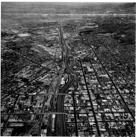
Figure 14The
automotive landsca pe of the Los Angeles metropolitan area. Photograph provided by California Deportment
of Transportation.
56
beyond (Banham 1971; Jakle 1990; Jakle
and Sculle 1994; Kling, Olin and Poster 1991).
Freeways
are the other ubiquitous imprints of auto culture in urban California. When Frederick Law Olmsted, Jr. proposed a
freeway system for Los Angeles in 1930, little did he realize he was laying the
groundwork for a landscape feature destined to alter not only the Golden State,
but much of America (Bottles 1987, 216-20).
Indeed, the completion of California’s first freeway in 1911 (the
six-mile Arroyo Seco Parkway near Pasadena) as well as the construction of the
Golden Gate and Bay Bridges in San Francisco during the same period assured the
ongoing centrality of the automobile in the state’s two largest metropolitan areas. Seen as a solution rather than as a problem
when they were created, many of California’s urban freeways are today among the
nation’s busiest with average daytime speeds of less than 20 miles per hour now
the norm in Los Angeles (Banham 1971; Birdsall, Florin and Price 1999, 352-54;
Bottles 1987, 19-20; Flink 1998, 140-45).
Finally,
auto-related industries have transformed major portions of the state. The first Ford assembly plant appeared in Long
Beach in 1911 (Shallit 1989, 119). Subsequently,
localities such as Van Nuys, South Gate, Oakland and Fremont were fundamentally
altered by the presence of space-extensive automobile assembling facilities
(Morales 1986; Nash 1972, 321-22; Rubenstein 1992). Associated new and used car lots occupy
thousands of additional acreage. California’s
petroleum industry also received a huge stimulus from growing demands for
gasoline and engine oil (Bottles 1987, 199-200; Nash 1972, 321-22; Shallit
1989, 109-25; Viehe 1981). Large oil
fields in localities such as Long Beach (Signal Hill), Whittier, Santa Barbara,
and the San Joaquin Valley witnessed tremendous growth in direct response to
the automobile’s never-ending appetite for fossil fuels, and oil production
remains an important part of the state’s economy·
Three
years prior to Pearl Harbor, anxious British war planners began transforming
California’s economic landscape. In June
1938, Lockheed Aircraft in Burbank received one of the state’s first big
foreign orders for 200 warplanes (Verge 1993, 4). Few realized at the time how momentous the
next seven years would be in reshaping the Golden State. Historian Gerald Nash stated it simply when
he wrote, World War II left an indelible imprint on the economy of the American
West. No other event in the twentieth
century had such far-flung influence” (Nash 1990, 1). Considering the magnitude
and persistence of the changes, particularly for California, it is difficult to
argue with Nash. During the war years,
57
over $35 billion was spent by the
federal government in California (ten percent of the national total), the state’s
manufacturing output quadrupled, per capita income doubled, and more than 1.5
million new residents flocked to the state (Johnson 1995,8; Malone and Etulain
1989, 107-119, Nash 1990, 1-6; Wyatt 1997, 158).
When
war arrived on December 7, 1941, California immediately felt the conflict more
directly than any other state. Indeed,
two weeks later, a Japanese submarine torpedoed the SS Absaroka just outside Los Angeles Harbor (Verge 1995, 23·-25). Soon, large barrage balloons hung above the
city (to entangle low-flying aircraft), the entire California coastline was
protected with ant iaircraft guns, and coastal residents adjusted to the
reality of nightly wartime blackouts. Other
ephemeral, yet profound landscape changes shaped the California scene (Beck and
Haase 1989, 74-78; Wyatt 1997). Prisoner-of-war
camps littered the Central Valley and American citizens of Japanese descent
were imprisoned at Manzanar (Owens Valley) and at Tule Lake (Northeast
California), leaving a quiet, yet powerfu l legacy on the landscape that still
scars America today.
Overall,
the war brought four fundamental changes to the California landscape,
alterations that remain apparent today (Nash 1990, 1-6). These enduring transformations included 1)
the dramatic industrialization and modernization of the state’s two largest
urban areas (San Francisco Bay and Southern California, 2) a broader set of
infrastructure and technology investments throughout the state which sparked
ongoing changes on the landscape, 3) the tremendous expansion of California lands
directly controlled and subsequently shaped by the military, and 4) the
sparking of an extraordinary population rush to the state that persisted for
decades.
Major
portions of the modern Bay Area and Southern California landscapes are directly
related to wartime demands for industrial production, upgraded port facilities,
and modernized urban infrastructure (Abbott, 1993, 3-29;Johnson
1993; Lotchin 1992; Nash 1990, 41-66; Shallit 1989, 170-92; Verge 1993). Port facilities in San Francisco (including
the Naval Shipyard), the East Bay (including Vallejo, Alameda, Oakland, and
Richmond), Los Angeles (San Pedro and Long Beach), and San Diego witnessed tremendous
expansion as they became organizing and collecting points for the military and
centers of war-related manufacturing (30 percent of America’s wartime ship
tonnage originated in the Bay Area and more than 4000 defense-related manufacturing
plants were located in Los Angeles County).
Indeed, those crucial World War II investments paved the way for the
state’s current role in trans-Pacific trade and the extensive port facilities
that make it possible (Lotchin 1992).
58
Many
major industrial landscapes of modern California have their roots in World War
II. Even as direct military expenditures
fell in the 1990s, the state still receives 20% of Defense Department spending
and almost 50 percent of NASA funding (Birdsall, Florin and Price 1999, 555;
Wyatt 1997). More broadly, while defense-related
manufacturing no longer dominates the state, many of today’s industries were attracted
to California precisely because of its war-spawned industrial infrastructure
and skilled labor force. For example,
General Motors, Quaker Oats, and Sylvania Electric all opened major manufacturing
plants in California immediately following the war (Verge 1993, 146). In addition, California’s high technology industries
grew from the presence of wartime concentrations of expertise and innovation in
localities such as Berkeley’s Lawrence Radiation Lab and at Stanford University
(Nash 1990, 1-6).
While
the Bay Area and Southern California were most dramatically transformed by the
war, broader changes in the state’s infrastructure were also initiated and have
persisted to the present. For example,
the state’s oil industry, still of crucial importance today, expanded greatly
during the war years (Shallit 1989, 1987).
Agricultural output also soared to feed the troops, and the war
generally hastened the state’s movement towards less labor intensive
agriculture as thousands of young men left the farm, many never to return
(Malone and Etulain 1989, 112; Shallit 1989, 187). In addition, both federal and state expenditures
for basic infrastructure expanded greatly, again oriented toward wartime
demands for better roads and airports, water supplies, flood control systems,
communications facilities, and electricity production (Lotchin 1992, 139-52).
The
military’s direct mark upon the California landscape owes a great deal to World
War II. It is no coincidence that more than
3.3 million acres of California remain under federal military control (United
States, Depart-ment of Defense 1995). That
legacy was fundamentally influenced by the war when dozens of new military bases,
airfields, shipyards, supply depots, training grounds, and testing facilities
were either created or greatly enlarged.
Major wartime investments in military facilities in-cluded collections
of distinctive military housing (remnants still remain on or near some bases), infrastructure
(airstrips, roads, and utility net-works), and large open spaces designed to
facilitate troop training and maneuver operations. More than a half-century later, sizeable chunks
of the Cali-fornia landscape remain parts of active military facilities. Examples include Fort Hunter Liggett
(purchased from the Hearst family near San Simeon in 1940) (165,000 acres),
Muroc (now Edwards) Air Force Base near Mojave (300,000 acres), China Lake
Naval Air Warfare Center (1,100,000 acres), and Camp Pendleton (186,000 acres) (Beck
and Haase 1989, 74-76; California Trade and Commerce Agency 1999; United
59
States Department of Defense 1995; Lotchin 1992).
The
recent deactivation of 29 militaly bases in California (as of Decem ber, 1999)
has thrown a new wrinkle into the evolution of these landscapes (California
Trade and Commerce Agency 1999). Facilities
such as Fort Ord, Mather Air Force Base, Alameda Naval Air Station, and the
Presidio (in San Francisco) have seen over 75,000 acres turned over to the National
Park Service, The California State Parks system, leased to municipalities, or
sold off to real estate developers. As a
result, facilities such as the Mare Island Shipyard (Vallejo) have witnessed a
process of adaptive reuse as old military buildings and open space have been transformed
into federal agency office complexes, industrial parks, and public golf courses. Further Defense department downsizing in the
future is likely to continue the process.
Perhaps
most significantly, the war brought millions of people to the state, some as
temporary workers, others merely as traveling servicemen bound for the Pacific. These shifting migrations set the stage for a
post war predilection to relocate more permanently to California. California builders eagerly met the pent-up
postwar demand for housing by applying their wartime skills in the mass production
of suburban communities (Hise 1997, 117-52; Johnson 1993, 87-91). Although it is impossible to measure the
precise impact of the war on the state’s long term population growth, the
pivotal years of the early 1940s produced a surge of economic investment and
migration that the state is still dealing with more than a half century later (Matthews
1999; Preston 1971,5).
National Environmental Policy
Act, January 1, 1970
Some of the most sign ificant determ i nants of
California’s landsca pe a re
those entities or
processes t hat stop or mod i fy human actions.
Pa rks and national forests, with thei r restrictive ru les. 1>erform that function. The National Environmental Policy Act (NEPAl and its offspring. the California
Environmental Quality Act (CEQA), also shape the
human landscape by injecting
scientific appraisal, public input. and mandatory ownership
of responsibility into
nea rly all development decisions. As platforms for environmentalists’ guardianship of the land. they have
•mmeasurably added to the state’s cumulative hu man landscape.
When President Richa rd N ixon signed
the NEPA legislat ion on
New Years Day, 1970,
it brought a new era of federa l land and resou rce man agement by implementing five mandates: (I) agencies must
strategi ca lly plan to minimize
environmental impacts
of their actions; (2) they must allow public input in the planning
process;(S) they must produce
an environmental impact statement CEIS) if there may be significant
60
envi ronmenta l effects
and eva lu ate a lternatives to
their proposed action;(4) they must cooperate
with other federal,state. and local agen cies; and (5)
they must usc an interdisciplinary.
place-based. and science-based approach to planning (Caldwell 1998; Council on Environmental Quality 1997; Fogleman
1990).
NEPA has had fou r ma jor effects. First is the aggregate of direct
effects on pla nning and
federal action. Foresters for the
U. S. Forest Service
mainta i n t ha t envi ronmentalists have used NEPA to effectively block logging, especially salvage removal of dead and down or burned
trees. TI1is in tu rn has preserved the forest ecosystem but also mod i fied it by
continuing to allow a buildup
of fuel (Stone
2000). 1n Sequoia and Kings
Canyon National Parks, NEI’A-mandated public input caused the Na
tional Park Service to increase the size of its proposed wildemess and eliminate a number
of•donut hole• exclusions where limited develo? ment could have
later occurred (Dilsaver and Tweed 1990). NEPA also
affects highway constmction using federal funds, management
of the Central Valley Project.
off-road vehicle and grazing policies on Burea u
of Land Management desert lands,
and any other projects i nvolving the federal governmen t.
The second effect of NEPA is subtler but no less profound.
Federal environmental management is so influenced
by the law that many ideas and
projects are rejected
out of hand because of the expectation of an
angry public reaction. likewise.
the stipulation for science-based evaluation has empowered natural and cultural resource scientists in planning and day-to-day management. Richard Sellars (1997) claims that NEPA was responsible for a large influx
of scientists into the National Park
Service and a movement of their role in pla nning to center stage.
The final impact
of NEPA was to encourage states to adopt simila r laws
and practices. In Cali fornia that took the fom1 of the California Envi
ronmental Quality Act. a body of law that goes much farther
than NEPA in shaping the state’s landscape. CEQA. passed later in 1970. has been shaped by court decisions to a greater degree
than has NEPA.
In one of the earliest and most important decisions. Frimds of Mammoth v. Board of Suptrl’isors (8 Cal.
3d 247, 1972). the court stated
that CEQA not only applies to actions
of state agencies, but also to actions requiring permits or oth er d iscretiona ry decisions fro m state or
loca l gover n ment
in Ca
l i fornia. This means any major development
i n
the state, whether
government or private, must foll ow the CEQA review process.
like NEPA. the CEQA process mandates scientific data gathering. an assessment of altematives and
impacts, issuance of an environmental
impact report {EJR) if there will be impacts. and public disclosure and
61
input. ,\ Jso like NE J>A
it has become a vehicle for environmenta lists’ actions to block projects.
Accord i ng to lhe California Legislat
i ve Affairs Office (1997), belw(-cn 35,000 and 40,000
projects per yCar are subject to
the CEQA process. Of these, up to 2000 per yCar require an EIR. Public input is a major factor.
In No OiL Inc. ‘ City of Los Angell’S (13 Cal. 3d 68,
197-l), lhe California Supreme Court stated
that public controversy alone demands an EIR (Varner 1992). In this case the city had attempted to quietly change
zoning to allow for oil exploration
in Pacific Palisades.
When an E l R is ncccssal’y, delays and project costs rise d rdmatica lly.
Hence it is used not only to assure environ mental compliance, but also to stall projects u ntil their proponents
have
lost interest or ca pital. According to Va rner (1 992), the usc of CEQA by N I MBYs (not-i n-my backyards) has d iscou raged many investors from even considering real
estate projects. Further more, as the CEQ/\
related caseload
bu i lds up.
the bureaucracy is less
able to cxpcditiouSI y handle it.
CEQA nol only affects
real estate and other developments
but has also been used to manipulate private industry resource usc, modify state water projects, save historic structures, and preserve existing
human landscapes O. ittleworth and Gamer 19951. A 199-1 court decision required the Pacific lumber Company
to conduct a wildlife survey
as part of an EIR before culling old-growth redwoods
(Carri7. osa 199-1).
The delay helped to forestall the company
long enough for the federal and slate
governments to negotiate acquisition of the area for preservation. In the late 1980s. h istoric preservationists successfully used CEQA lo save an
h istoric lntss bridge over the Russian River.
A CEQA delay discouraged a developer in Sa nta Ba rbara from razing a n eocolon ia l omcc
bui lding
i n order lo bui ld a new office-i
ndustria l complex. After opponents re jected a plan lo move the old build i ng. the developer modified his plan
to i ncorpora te il into the new com plex (Freeman 1 990). Aga i n l ike
NEPA, the CEQA process has brought
acute awareness of the environmental (defined in CEQ/\ to include the human environmental) effects of any action or policy. If only to avoid litigation, agencies and dc,•elopers must be
aware of the import of their decisions. Environmental
accidents• are thus less likely. Change has been slowed perceptibly on the sl. llc’s lands.
A major criticism of both CEQA and NEPA is that they drC proj(‘Ct spe cific and defeat coordinated general planning (Varner
1992; Stone 2000). Others, including Olshansky
(1996) and Rubens and Dclv,,c(J991), chal lenge this opin ion. I lowcvcr, cou rts in California have held tlldtthe
EIR process must lake into account the cumu l at i ve significance of a project.
I n a San Frd ncist’Ocase the court noted that "wilhoul such control, piecemeal
devclopmcnl would i nevita bly cause havoc in virluully every aspect of
lhc ur ba n en v ironment• (quoted
i n R ubens a n d
Dclvac 1991 , 37).
62
·n,e federal
Council on Environmental Qual
ity has adopted sim ila r ru les for
analysis under NEI’A of thecumldati. . c i mpact of myriad
small decisions.
The SliJ>ulations
under both NEPA and CEQA to plan on the basis of cumulative impact further enmeshes
land management in a vely public,
often acrimonious, attempt to shape the
environment and landscape towards a vision imagined
by human society. The cumulative impact
of the two Jaws is impossible to quantify. Given the massive population increase in the state
since their enactment and the development demands that it has brought. these checks
on piecemeal. sometimes
ill-(:onsidcrcd development a re perhaps among the most extensive
of California land cape shapers.
The evolution of the California landscape was hardly
the concern of Intel Corporation engineers as they perfected a dramatically
improved microprocessor in their lab facilities late in 1975. As technology histo rian •\lichacl Malone
0995, 18-19) argues, however, "hislOI’y may well
rccogni7. c it (the 8080 microprocessor) as the most important
single prod uct of the 20"‘
century. ‘ Indeed, its inftuence across California, across all of the American
landscape, has been so widespread, so ubiquitous that il
is almost impossible to imagine modern life without it. Within the Golden State, the computer revolution il fueled (including the intro d uction of personal t’Ompulers and software
(1970s), computer networking (1980s), and the Internet (1990s) resha peel t h e state’s econom
i c geography and cullural landscapes in fu ndarncnlal w. tys (Winslow 1995). l’erhaps i l was only dppropri ale thal lnlcl’s discovery look place in Cali fo rnia: si nce 1973. Cal i forn ia ns
have been Ameri ca’s co nsu mmate
compu ter consumers and prod ucers, both wit h profound geographical implic:Mions (Cali fornia Trade and Commerce
Agency 2000;Ceruzzi
1998). California is home to more computers than any ot lwr state and their omnipresence has fueled
the profound deccnlrdli7. alion of cities as well
as the growth of many previously isolated
naral areas. As the leading
producer of computer-oriented high-technology hardware, the slate’s
landscape is also liberally littered
with manufacluring facilities. research centers, i!nd
associdled communities, all oriented around producing the myriad products that followed
the fateful introduction of Inlets 8080 innovation.
California’s urban environ ments, and their spatial
propensity lo sprawl,
a rc direct ly related
to lhe ubiquitous presence of the m icroprocessor in cvcl’yd
ny life. From our morn i ng a lar
m docks and coffccmakcrs to the evening entertainment on our sa tellite-
or cable-fed television
sets, the
high-tech world has refashioned the landscape
at many scales (Malone
1995, 28-30).
Most importantly. it has allowed
many Californians to work
away from a traditional office
setting. thus freeing them from the need to
locate near the central city.
For thousands of California businesses, it has allowed
for the electronic centralization of information, while at the
same t ime permitting the spatially dispersed utilization of that infor mation. Simply put,
ponder
the
flowering of sma ll branch banking.
brokerage. and insurance operations as well as the growth of suburban
reta
i l ing outlets, all seamlessly l inked to larger parent
compan ies and nationa l or global
econom ic networks by those glowing
screens perched on a lmost every
office desk. Out on the suburban boulevards beyond, the humming traffic signals,
glowing streetlights, and the automobiles themselves resonate
with a similar high-tech harmony. Even
the pedes trians fumble with their palm-held
electronic devices, while commuters pass
the lime in traffic on their cell phones. The spatial implications are dear: all of these innovations are enabling people, information,
and economic activities to move more easily
across the Ca liforn
ia landscape and to faci li tate the dispersal of urban activities beyond the central city
(Abbott 1993,
1 23,
170-71 ). The recent grow th of the I nternet is cont i nuing the pattern and
it is no coincidence
that ZD Nes
10 •Most
Wired Cities and Towns in America• include three large urban areas in
California (San Jose, San Diego, and San Francisco) (ZO Net 2000).
Indeed, the microprocessor reaches far beyond the slate’s
metropolitan heartland into even its traditionally mral recesses. Personal computers,
fax machines, modems, and the immediate connect. ivity oflntemet com munications-all a direct
outcome of the microprocessor revolution-have made it
much
easier for ind i viduals and sma ll busi nesses to loca te in
high-amenity
non
metropolitan
portions of the state. Indeed.
as demog
rapher Kenneth Johnson (1999) has recently
demonstrated, there is a widespread and
national "Rura l
Rebound"
shaping the cultura l land scapes of hundreds of America’s non metropolitan counties. Fueling the turnaround are communications advances
that have freed businesses "to
select nonmetropolitan locations and enjoy
their perceived advan tagesO·
ohnson 1999, II ). In California,
for example, Johnson’s data re veal siz:. 1ble population
gro\\1h rates in every nonmetropolitan county
in the Sierra
foothills as well as a ll across the northwestern part of the state. Other recent studies confirm
the pattern and its causes.
Duane’s
0999) detailed
economic and socia l assessment of the Sierra
foot h i lls cites su bstantial
population and economic growt h i n co mmunities such
as Sonora, Placerville, Grass Valley. and Nevada City,
linking the phe nomenon to
thegeneral benefits of the technology revolution as well
as to the recent inmigration of high-tech firms into nearby portions
of the eastern Central Valley Ontel in Folsom; Hewlett Packard in Roseville, etc.
). Smaller companies such as
Educational Management Solutions
(Murphys), IntegraTech (computer consulting) (Placerville), and DuoCor, Inc. (computer data systems) (Nevada
City) also illustrate the ability
of new economic activity-often high-tech in nature-to focus in the midst of
such nonmetropolitan settings.
Hundreds of California loca lities d irectly renectthe
importa nce of high technology because
the state out produces all others in the manufacturing of compu ter
ha rdware and software products (Ca l i fornia Trade and Com
merce Agency 2000). Silicon Valley (includi ng much of Sa nta Cla ra and po
rtions of San Mateo counties)
remains the hea rth of
such innovations and its cultural
landscapes reveal what must be the most dramatic and tangible imprint
of the high-tech world upon the Golden
State (Matthews 1999; Saxenian
1985; Shallit 1996; Winslow 1995). The statistics are mind-boggling: in 1999 roughly one-third of the world’s high-technology investment capital flowed into California’s Silicon Val Icy. and more than 250,000
new jobs were created in the area between
t 992 and 1998 (Economist 1 999). Technology heavyweights such as Intel. . llewlctt
Packa rd, Cisco Systems, Sun Microsystems. Oracle, 1111d
Yahoo! ca ll the Va lley home. Their landscape expressions i nclude the sprawling manufacturing and office facilities of the companies
themselves, an impressive infrastmct ure of roads, schools,
and parks (financed through the high-tech lax base), scores of upscale shopping
complexes and luxury car lots (the Valley boasts
250,000 millionaires), and the opulent, exclu sive residential neighborhoods (Woodside,
Portola Valley.
Cupertino, Palo
Alto, Atherton, etc. > that house owners and workers lucky enough
to be feasting u pon the fmits ofthe latest stock options
or initial public offerings (Kaplan 1 999).
Importantly. the Silicon
Va lley served as the site for the
Stanford Resea rch Institute (SRI) in 1 946, a 660-acre high technology
i ncubator and industria l park (one of the nation’s first),
originally associated with Stanford University (Cemzzi 1998; Saxenian
1985). Not only did SRI succeed
in attracting many major computer-related companies to the area, it also served as a larger model of how such facilities should be designed and
laid out on the landscape.
Under the SRI model. such high-technology manufacturing operations were designed
to have a campus atmosphere, featurespatially extensive one-or two-story buildings,
and support
aesthetic l andscaping and employee amen i ties (pa rk-like
open areas, sports facilit
i es. convenient pa rking>, a ll designed to crea te an image of a clean, modern, efficient, and pleasant
work place (Abbott
t 993, 62-63; Findlay 1992, 117-59).
The model proved
tremendously
attractive. a prototype of the late twentieth-centu ry industrial
land
scape which has diffused to many other parts of California as well as
the world beyond.
 65
65
Today. California boasts m3ny additional Silicon Valley ·wannabees" that reveal the ongoing
impact of high-technology
manufacturing upon the state well beyond the bounds of the famed
South Bay region. Indeed, a recent Wall Street Journal (1999) survey of Americil·"New
1\llap of lligh Tech" fea tured 1 3 nationa l
"hot spots. " including four in
Ca li forn ia. In addition to Silicon
Valley. Ihe survey noted the growth of compu
ter hardware, soflwarc and Internet-rela
ted businesses in San
Francisco (Web startup companies in "Multimedia Gulcll"
south of
1\larket Street). the "Digital Coast" (including Ventura, Los Angeles, and
Orangecounties), and San Diego and its
nearl>y suburl>s (La Jolla,Sorrento Valley, etc. >. Other firms are seeking
locations ncdr Sacramento and in varied nonmetropolitan localities beyond (Duane 1999,
84, 109-1
1 0). The result is a California cult ural landscape
increasingly punctuated with
the omnipresence of technology. Indeed, whether it is a high-tech stilrtup firm in some suburban
or small-town community or the subtler signature of a nickering personal computer screen
in a home office, the microprocessor revolution has fundamentally reshaped
the California landscape.
Ca l ifornia
is a state with extraordinary
topographic and ecologica l diversity. At first glance its landscape
is dominated by mountains and broad, flat valleys. deserts. bays. and steep coastal cliffs. It is a powerful canvas upon whim the actions
and alterations of humanity
are painted. Yet it is the accumulation
of those humiln activities that shapes the vi5tl11l and experi entia l landscape encou
ntered by peopl e whose connection to the natural world grows less t(mgible with each techno logica l innova
tion. Understand i ng the evol uti on an d expression
of California’s human landscape is critica l to understanding society and culture in this remarkable corner of the earth.
From at least 15,000 years ago. humans have cumulatively acted upon. managed, and accidentally or deliber,1tcly altered
the natural world
in California. Nearly every aspect-landforms. soils. vegetation, fauna.
and hydrology-has been mod ifi ed. Earn addit i on. subtraction,
or rclocdtion altered a landscape b(1se already humanized
by
previous people. I Iu man h istory in California may be likened toil
river that consists of the water
of many thousands of tributaries.
Each new addition alters the width, color.
turl>ulencc, and direction of flow of the river. But earn
tributary adds to a set of riparian conditions ,1lrcady well established. Some tributaries are insignificant while others rildically alter the look and
bt’llilvior of the connut•nt river as surdy (IS the Missouri ,)Iterthe M ississippi.
We have tried to
iden
tify tht• foOccn most i mport(ml tribu taries in the river t hai is California’s visual
landSCdpe. The event that
66
marks earn confluence has mingled with and
adapted to the existing flow while fundamentally cllanging it.
Earn of the fifteen events we
have chronicled is part of three broad trends-increasing popu lation. growing technological prowess, and an exploding demand for space and resources exponentia ll y greater than
the population increase itself. Every
environmental and h uman ele ment has evolved accordingly. The
geomorphology of the sta te ileast affected but not
immune. Indian burning modified erosion processes while Spanish
and American water transfers have brought this to a new
order of magnitude. Mining. suburl>an
development. and the road cuts of
thousands of highways and
rails shape the land on a local scale.
Mod i fication of the hydrology of California has been a long saga culmi
n ati ng in the most complete spatial manipulation of wa ter in the world. Event after event influenced California’s most important resource and, hence, everything else dependent upon it. The Spanish
introduced the appropriation doctrine.
The gold rush brought elaborate
flumes and distribution systems. Tile railroads added organizational frameworks. Urban needs spawned
the Los Lobos Creek diversion, leading to arteries of water that feed the state’s cities. The Wright Act adopted appropria
tion and established
the framework for irrigation districts and massive
interl>asin water transfers. Eacll innovation
built on the knowledge and the technology
of the previous hydrologic manipulators.
Tile biogeography of California is perhaps the clearest
example of the mingling of new processes
with a landsca pe mum
modified by their predecessors. Indians
burned California for thousands
of years and shMply altered the profile of the fauna thdl also shaped
the fore ts and grasslands. Palcogeographers
have only begun to research
the magnitude of the changes they wrought. ·n1e Spanish shattered Indian numbers and culture sending drastic reverbera tions through the ecosystems. At the same
time they and later immigrants introduced hundreds of exotic plants and animals many of which are now domi
nant species throughout the state.
Americans accelerated this process,
bri
nging thousands of additional exotics, logging for the gold mines. and expanding their settlements in area and dist ribution
wit h the aid of
milroads and automobiles. They flowed in to the slate i n vast, resource demd
nding num bers drawn by
suburbs. cheap electric power, World War
II, and a computer industry that dominates the nation. National forests and parks blunted
this assault on the forests,
yet even there the
deliberate suppression of fire modified natural communities. Drainage of lakes and wetlands. the expansion of dgricu
lture. drastic mdnipula
t ion of the faum1, and the reorientation of the hydrology also added to
the ecological transformation. Yet each
built upon a b11sc already humanized by the first Native Californian fire.
67
 Even more visua ll y recognizable
are the structures added to the land scape by successive waves of humanity. At the most basic level. there are the lines on
the
land. Township and Range property Jines. city boundaries
derived from Spanish land grants. roads. urban street patterns.
railroads.
power lines. aq ued ucts. and the neat rows of irrigated crops punctuate all but the
most ruggedly unfriendly environ ment.
Then there is the pattern of sett lements. The Spanish chose the coast and loca ted
ncar concent ra t ions of I ndia ns. Irrigation, m ines. ra i l roads, n
nd s pecialt y agricu lt ure gave economic stre ngt h and popu l at ion
t o some towns and regions while dcnying them to others.
Technological innovations
such as suburban
ra ilroads. computers, and, more
than anyth i ng else. the automobile led to new residentia l and comm ercial forms and their sprawl across the sta te. Mobility, the Hispanic heritage. and the Internet
have helped sha pe the architectural display
of California’ssettlements.
And.
underlyingeach and every settled place
is the presence of water brought
from near and far.
Even more visua ll y recognizable
are the structures added to the land scape by successive waves of humanity. At the most basic level. there are the lines on
the
land. Township and Range property Jines. city boundaries
derived from Spanish land grants. roads. urban street patterns.
railroads.
power lines. aq ued ucts. and the neat rows of irrigated crops punctuate all but the
most ruggedly unfriendly environ ment.
Then there is the pattern of sett lements. The Spanish chose the coast and loca ted
ncar concent ra t ions of I ndia ns. Irrigation, m ines. ra i l roads, n
nd s pecialt y agricu lt ure gave economic stre ngt h and popu l at ion
t o some towns and regions while dcnying them to others.
Technological innovations
such as suburban
ra ilroads. computers, and, more
than anyth i ng else. the automobile led to new residentia l and comm ercial forms and their sprawl across the sta te. Mobility, the Hispanic heritage. and the Internet
have helped sha pe the architectural display
of California’ssettlements.
And.
underlyingeach and every settled place
is the presence of water brought
from near and far.
Fi nally. Ca li forn
ia is a culture and a cu l t ural expression. It is an innovator.
Western water systems, su bu rbs, na tiona l par ks, and la
rge monocul t ura l agricult ure started or extensivel y developed in the slate. On the other hand, railroads, automobiles, electrification. and thousands of other
influences ca me from the broader
American experience. The Spa nish
left a legacy that is more strongly
fell in modern Hispanic neighbor
hoods than elsewhere. The mines and then railroads
brought the Chi
nese
while racism concentrated them in urban ·ChinatownsCalifornia, as the end of the migratory trail for so many years, developed
a vibrant and adaptive
culture according to Pa rsons 0955). This has drawn Asian and
Latin American immigrants
in large numbers as well as other groups
from with in and beyond the United States. Each group
has
imprin ted its identity on portions of the Ca li fomi11 landsca
pe. The migra tion
t hat has spawned Parsons’ cu l tura l adaptabi l it y stems from each and every even t we have identified.
During the development of ideas for this article we considered
more than t 50 separate
human events that led to processes
that have shaped the visual landscape of California. We believe we have identified the fifteen most influential ones a lt hough we stand ready to receive sug gestions and arguments for others.
From time to time we asked others
for
thei r ideas and received a number
of suggestions that
usu ally but not always agreed wi th ou rs. Some geogra phers insisted on including nat ural occurrences despi
te our stipulation tha t they must be human generated events. This points out one limitation of our essay.
I Jumans never act entirely outside the natura l world. Three events, the drought
of 1862-63, the Dust Bowl and the Long Beach earthquake of t 933. come to mind as modifiers of human actions
and adaptation. Yet it is
68
the human imprint on
the
land that we seek to ‘;’ndcrst nd and we posit that the events we have named are the most . nflucntoal.
To anticipate a question
that may arise in readers’
minds. he next five events on our list were the
establishment of the movoc ondustry, the arrival of the airplane
in Cal ifornia, the Williamson Act which has
helped
preserve agricultural space, the Nati?nal Historic Prescrvatin Act (80
Sta t. 915). and the Centra l Valley ProJect. The l atter
wa s a poon t of d os
cussion beca use a lthough
we have shown t hat
the Wright Act led directly to i t, water ma n ipu lation in Cali fornia
is of such import that we
were tempted to devote three events to
it.
In sum, a review of the human
imprint on California’s landscape. the
look of the natural environment, the spatial pattern
of settlement and
economic activity. the size and character of structures. the latLiccwork of
lines.
and
a myriad of other
elements poi nts to the liftn events . we have described
as most crit ical. A look at any geographocal questoon
wi ll demonstrate their i mport. Why are there vineyards near Los Banos?
The Spanish i ntrod uced the crop, the gold rush famili(o rizcd Americans
with wine, the cumula tive legacy ofw(o ter mano pulatoon led to the Cah
fornia Aqueduct, transm i ssion
lin es bri ng electricit y to power the
aqueduct’s pumpingstations, Interstate5 brings
the trucks,suburbs house some
workers. and computers allow state of the art management
and technology to easily reach this quiet comer.
And what of the future? Will these remain
the most significant fifteen events as new. possibly revolutionary changes in human
cult u re . and tL>(:hnology occur? Computers may int rod uce even greater adatatoons in
lifestyle and resou rce demand. Dependence on the automobolmay wa ne to some degree. The environ mental movement. expressed
o n the parks and forests of the sta le, may
strengthen
and redaom more tern tory
for the forests and wetlands
that
are themselves hu an ied constructs. Will the influence of the lndoans ever become an hostonc?l curiosity rather than a living factor in the appearance of the Cahfooa
scene? While great events will occu r in the future
possobly dosplacong some of ours
from the top fifteen. these that we have presented will continue to play a role. Short of tcarin¥ a house
compltely down we
con
tinue to build on the same foundatoon. Short of razo ng the human
impri nt on California, all tha t
follows will be shaped by these fifteen
events.
Rercrence. s
Abbott, Carl. 1993. Tht ;\ldropolliGil fronhtr. Citin ln the:\lodtm Jlmtri(tm \\isl Tucson.
AZ:.
University of Arizona Prns. , .
Andtrson, Kat . \ l and Moratto. . Michael. 1996. Na. tivt: Am(‘nr. ln Und Usc- Pr. ct:KeS
69