 Project Title:
Climatic effects on terrace formation in the Ventura area,
California
Project Title:
Climatic effects on terrace formation in the Ventura area,
California
Mendenhall Fellow: Richard V. Heermance, Western Earth Surface Processes Team, 530 N. Park Ave, Tucson, AZ 95719, (520) 670-5508, rheermance@usgs.gov
Start Date: March 19, 2007
Education: Ph.D.,
Research Advisors: Research Advisors: Robert Powell, (520) 670-5505, rpowell@usgs.gov; Jonathan Matti, (520) 670-5577, jmatti@usgs.gov; Chris Menges, (520) 670-5022, cmmenges@usgs.gov; John Tinsley, (650) 329-4928, jtinsley@usgs.gov; Martha Eppes, University of North Carolina, Charlotte, (704) 687-3498, meppes@uncc.edu; Gary Landis, (303) 236-5406, g_landis@usgs.gov; John Chesley, University of Arizona, (520) 621-9639, john_chesley@espri.arizona.edu; Ari Matmon, The Hebrew University of Jerusalem, 972 2 658 6703, arimatmon@cc.huji.ac.il, Scott Minor, sminor@usgs.gov, Jay Quade, Dept. of Geosciences, U. Arizona, quadej@email.arizona.edu
Project Description:
Fluvial
terraces result from past episodes of active erosion and/or deposition within a
landscape, and thus can provide clues to past climatic regimes surrounding the
time of terrace formation. Within
mountainous regions, the processes that form terraces, such as changes in
discharge, sediment supply, or tectonic uplift, are also factors affecting
sedimentation rate, grain-size variability, and facies changes within
basins. Thus a causative link exists
between subareal terrace levels and sub-surface depositional units within
adjacent basins. Unfortunately, the
relationship between surface geomorphology and subsurface-deposits can rarely
be unambiguously defined due both to lack of stratigraphic continuity between a
basin and its hinterland and to poor age-resolution from the terrace remnants
or the adjacent basin. Further
complicating issues is the poorly understood climatic controls on terrace
formation, specifically on what causes rivers to stop incising and erode
laterally (thus creating terrace straths) and over what time-periods lateral
erosion and incision occur.
This
project will use cosmogenic isotopes (10Be, 26Al) to
determine surface ages on the multiple levels of fluvial strath and fill
terrace-surfaces along the Ventura River, CA.
This suite of ages will be temporally correlated with a detailed record of climate change and
sedimentation from the adjacent
STUDY AREA
The
western Transverse Range of Southern California north of the city of
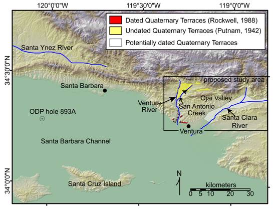
Figure 1: Shaded relief digital elevation model (30m) of the proposed
study area in southern
METHODS
Fluvial terraces along the
Terrace ages will be determined
primarily from in-situ produced cosmogenic isotopes (10Be, 26Al). These isotopes are produced from exposure of
Si and O atoms at the Earth’s surface, and their production rate is a function
of time, depth from the surface, elevation and latitude (Lal, 1988). By sampling a depth profile of recent (<1
m.y) deposits, in this case fluvial terrace deposits, an inheritance-corrected
depositional age of the surface can be determined. In addition to cosmogenic
sampling, organic debris will be collected from within the terrace deposits
overlying each strath for 14C dating. The combination of 14C and
cosmogenic ages will allow us to determine surface abandonment surfaces and
depositional age of the alluvium, as well as permit cross-checking of our
geochronology. Furthermore, shielded
samples with known inheritance collected at depth within terrace deposits will
provide regional erosion rates from the time of deposition.
The science goals of this project
mesh with objectives of the USGS National Cooperative Geologic Mapping Program,
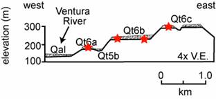
Figure 2: Schematic cross-section through strath-terraces on the lower
reaches of the
ANTICIPATED RESULTS
New geochronology of the sequence of terraces
from the
Recent drilling by the Ocean
Drilling Program (ODP) in the Santa Barbara Channel of hole 893A (Figure
1,Kennett, 1995) provides a detailed, 14C-dated record of
sedimentation (Figure 3A) back to greater than 160,000 years before present
(y.b.p.). Studies of the cores also
reveal δO18 changes
(Figure 3B) from benthic foraminifera that record past ocean temperature, and
can be used to infer past regional climate conditions. This high-resolution drill-core record
provides a unique opportunity to correlate basin sedimentation and local
climate with sub-aerial terrace ages from the adjacent mountain range in the
Preliminary
comparison of terrace levels with ODP core 893A indicates a general correlation
between climate and terrace age, although errors in the terrace ages make the
correlation ambiguous (Figure 3A, 3B).
Three of the five terraces (Qt6c, Qt6b, Qt 4) were deposited, at least
in part, just after the peaks of glaciation at oxygen isotope stages 5b, 4, and
2. These terraces imply that strath
formation occurs during or just after times of maximum glaciation, associated with
high sediment supply and hydraulics associated with a cooler, wetter climate
(e.g. Bull, 1991). But the current
resolution of the data is not sufficient to detect any consistent correlation
between the drill core and terraces. At present, a detailed comparison between deposition
rates and terrace formation is not possible for three reasons: 1) the age
uncertainties on the terraces are too large, 2)the chronology of deposition has
not been refined through tuning, and 3)only one detailed record exists from the
adjacent basin at this time. All of these restrictions will change during
this study. First, more absolute ages with improved resolution will define more
accurately intervals of terrace formation. Second, the strong correlation
between the
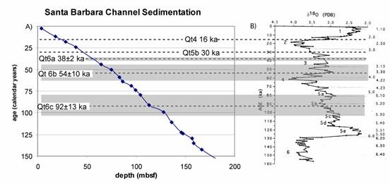
Figure 3: A) Plot of age versus depth for ODP core 893A (Kennett, 1995),
showing relative rates of sedimentation (flatter = faster sedimentation,
steeper = slower sedimentation). Dashed horizontal lines show the age of
fluvial terraces (Rockwell et al, 1984, 1988) with the gray regions indicating
1 sigma error around the age. B) δ18O plot for benthic
foraminifers for ODP hole 893A from Kennett (1995).