Unit 012
Astronomical Coordinate Systems
Objective:
This activity introduces coordinate systems that are used in astronomy to describe the positions of celestial objects in space.
Background:
Consider a situation in which you are observing
a celestial object and wish to communicate to another person where to look in
order to view the same object. How would
you describe it if you were speaking to somebody over the phone? Would you need a different description if
they were located in
To fix the position of astronomical
objects in space, we need a frame of reference, or coordinate system, which
assigns a unique set of numbers to each point in the sky. Each coordinate
system we will introduce has a particular use in Astronomy.
The first coordinate system we will introduce is the Terrestrial System. This is the familiar system of Latitude and Longitude that locates positions on the Earth. The observer’s location on Earth determines the sky they will see. The sky appears quite different at say the North Pole and the Equator.
The second system, the Horizon System, describes the position of objects local to an observer at a given position on Earth. We only need Azimuth and Altitude to fix a star’s location in the sky at a given time.
The third system, the Equatorial System, fixes the position of astronomical objects on the celestial sphere.
The Terrestrial System
This coordinate system is based on Latitudes and Longitudes, which are commonly used for navigation on earth. The terrestrial coordinate system is shown in Figure 1.
·
Latitude
Lines of
Latitude run east and west for a given point on the Earth; they are parallel to
the Earth’s Equator. The Earth’s Equator is at 0 degrees Latitude and the North
Pole is at 90 degrees Latitude.
·
Longitude
Lines of Longitude run north and
south from a given point on the Earth. The Prime Meridian or the line of 0 longitude runs through
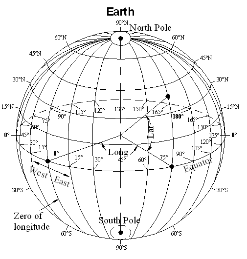
Figure 1. Terrestrial Longitude and Latitude
The Horizon System
The Horizon system is ‘local to the observer’ because it doesn’t involve any geographical coordinates. It is defined by the coordinates Azimuth and Altitude as shown in Figure 2.
·
Azimuth (Az)
Azimuth is measured eastward in degrees, beginning at the direction North. North is at 0 degrees, East at 90, South at 180, and West at 270.
·
Altitude (h or A)
Altitude is measured from 0° to ±90°, + is toward the zenith, the position directly above the observer head, and – is toward nadir, the position opposite the zenith.

Figure 2. The Azimuth, Altitude and Zenith
The Equatorial System
Another coordinate system used in Astronomy is the Equatorial System. The Equatorial System is a projection of the Terrestrial System onto the Celestial Sphere.
·
Declination (DEC)
Declination is measured in Degrees from 0° to ±90°
Declination may be thought of as latitude projected onto the celestial sphere.
·
Right Ascension (RA)
Right Ascension is measured in hours, minutes, and seconds from 0 h to 24 h.
Right Ascension increases in an eastward direction. The location of 0 h is the point the Sun crosses the celestial Equator going from South to North. This point is also called the first point of Aires. Right Ascension is referenced to the Equator. Measured on the equator 1 hr of Right Ascension equals 15 degrees of Arc.
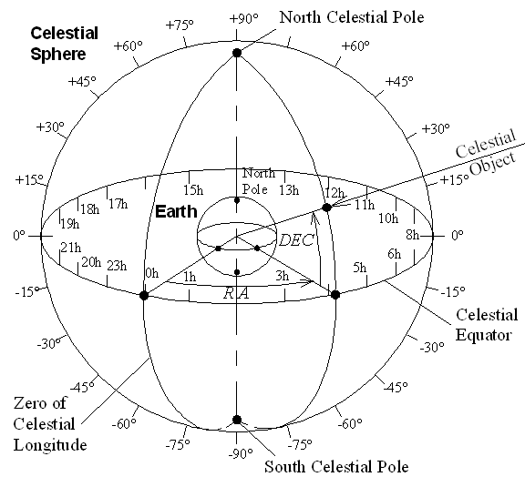
Figure 3 Equatorial coordinate system
SKILL: Star Map
For this exercise you will be using the SC001 Constellation Chart. The chart design is displayed in Fig 4.
Figure 4 Equatorial Star Chart design.
On this star map the celestial equator runs horizontally across the middle dividing the map into two hemispheres. The northern hemisphere is at the top and corresponds to positive declinations. The southern hemisphere is at the bottom and corresponds to negative declinations. This star chart shows regions of the celestial sphere near the celestial equator, from -60° to +60° declination. For regions near the celestial poles, one needs to refer to a polar star map.
The annual path of the sun through the constellations, called the ecliptic, is displayed as a wavy line running horizontally across the map and crossing the celestial equator at the center of the chart. This point is called the vernal equinox, the point at which right ascension begins. Notice that the right ascension increases moving left.
The dots on the chart represent the stars; the bigger the dot, the brighter the star. Other objects, such as nebula, double stars etc. are represented by other symbols. Refer to the key at the upper left and lower right of the star chart.
The names of the constellations are also displayed in capital letters. The pictures which represent the constellations have been outlined by dashed lines. However, modern definitions of constellations are regions of the celestial sphere. Unfortunately, this chart does not show the actual boundaries of the constellations. For this exercise it will be acceptable to assume that a constellation is made of the stars and the surrounding region.